Weather
Bomb Cyclone Storm Threatens MA With 60+ MPH Winds, Blizzard Conditions: Latest Forecast
A very powerful ocean storm will likely bring hazardous and damaging conditions to coastal locations this weekend.

MASSACHUSETTS — A powerful "bomb cyclone" storm off the Atlantic coast could bring blizzard conditions to parts of Massachusetts this weekend with 60+ mph winds, heavy snow, erosion and flooding potential amid astronomical high tides.
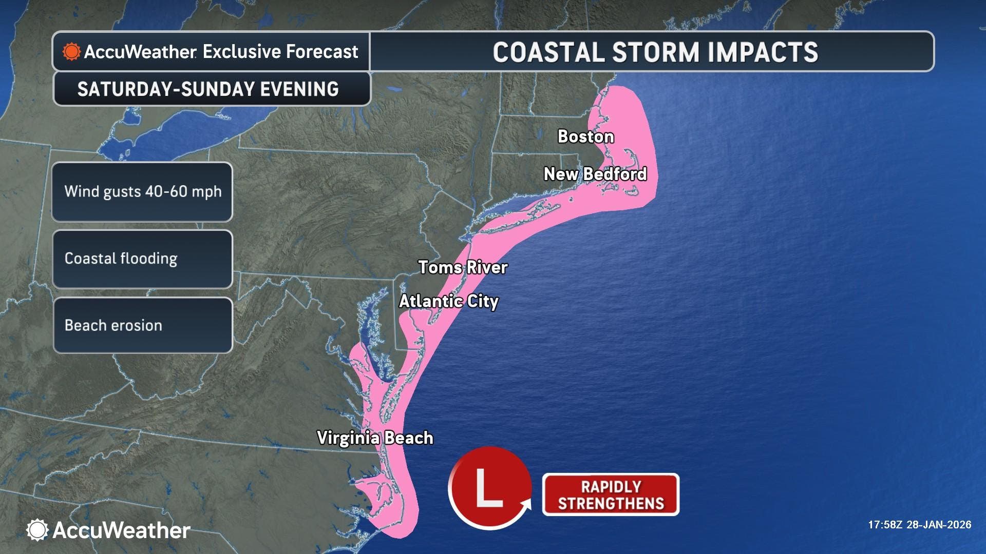
"Strong winds and rising seas will push water onshore from North Carolina to New England, producing coastal flooding and beach erosion," AccuWeather Senior Meteorologist Scott Homan said. "With a full moon this weekend, astronomical tides will be higher than normal. That means even a modest storm surge can push water much farther inland than people expect.
"Coastal residents need to be prepared for flooding near high tide."
Find out what's happening in Across Massachusettsfor free with the latest updates from Patch.
- North Shore Town To Give Snow Piles Burial At Sea After Massive Winter Storm
- Top 10 All-Time Snowstorm Precedes Bitter Cold Stretch: See Final MA Snow Totals
AccuWeather said water levels could surge 2 to 4 feet above normal at high tide in coastal parts of New Jersey, North Carolina's Outer Banks and New England.
The storm is forecast to rapidly intensify into a "bomb cyclone" along the southern Atlantic coast on Saturday, with atmospheric pressure plunging at least 24 millibars in 24 hours or less.
Find out what's happening in Across Massachusettsfor free with the latest updates from Patch.
AccuWeather experts say more than 5,000 flights could be cancelled across the country Saturday through Monday.
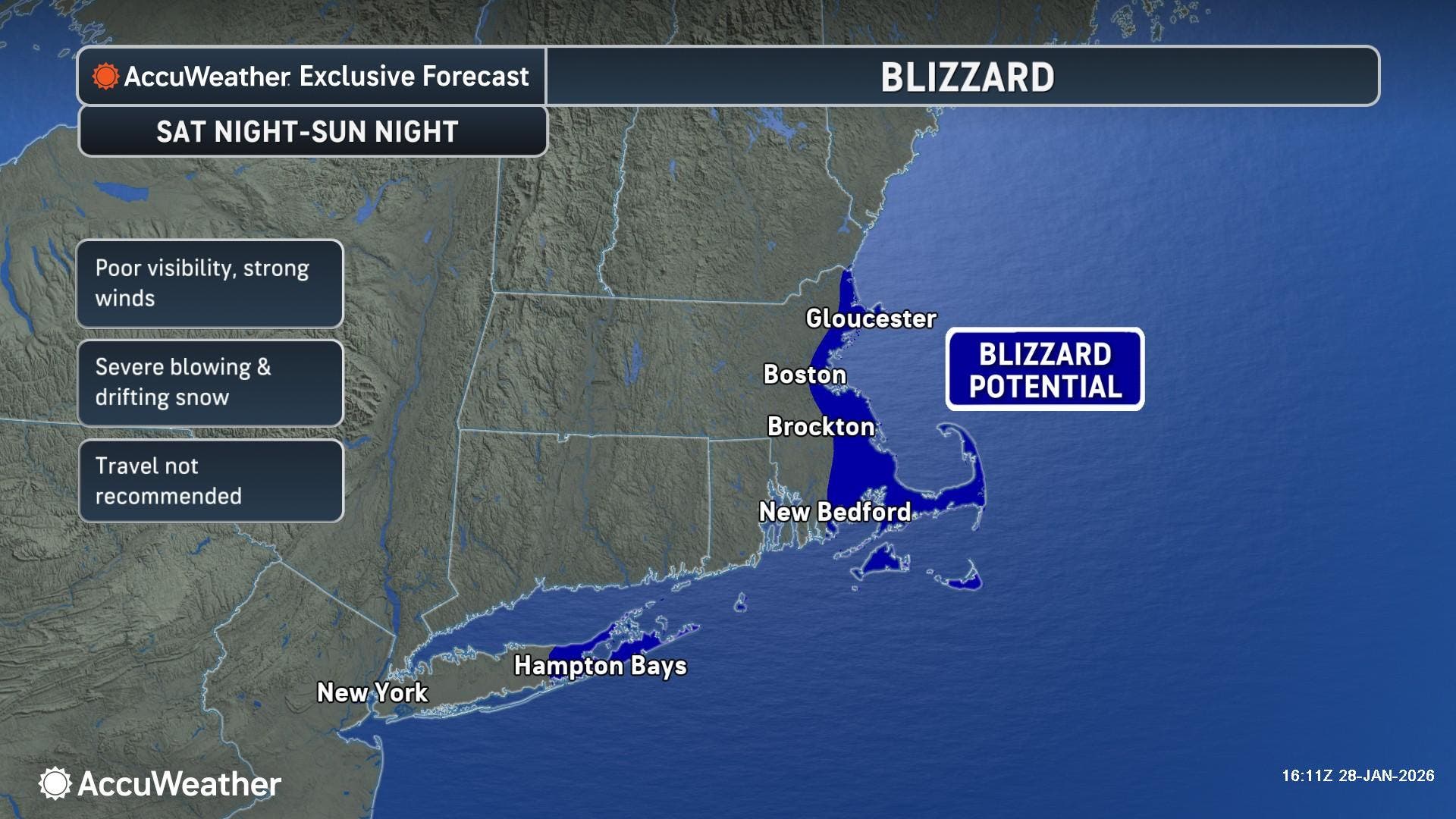
"Blizzard conditions may reach parts of Long Island and southern New England," Homan said.
That said, the question that remains is how much snow will reach how far inland in Massachusetts for a storm whose track may have it just out of range of being a direct hit for New England.
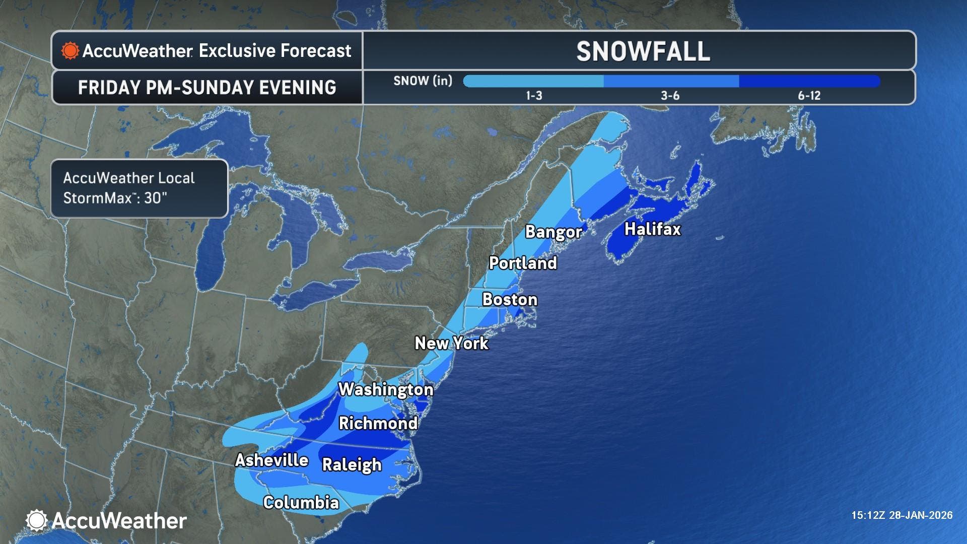
The Cape, Islands and southeastern Massachusetts stand the best chance of seeing near-hurricane-force winds, flooding and snow that could range up to 6 to 12 inches.
Accuweather said snow totals could drop off rapidly to the north and west, with a moderate chance of 3 to 6 inches of snow in Greater Boston, and lesser amounts the further away you get from the coast.
The relentless stretch of arctic air all but ensures that any precipitation that falls will be in the form of snow.
AccuWeather said the blizzard conditions are possible at times late Saturday through Sunday across parts of coastal New England and Long Island.
Prior to the storm, a Cold Weather Advisory is in place for Massachusetts from 7 p.m. Thursday night through 11 a.m. on Friday. Wind chills could reach 20 degrees below zero with low temperatures near zero overnight.
"The cold wind chills as low as 20 below zero could result in hypothermia or frostbite if precautions are not taken," the National Weather Service said. "Use caution while traveling outside. Wear appropriate clothing, a hat, and gloves."
Friday will be the coldest day of the week with a high of 16 degrees and wind chills staying below zero throughout much of the day.
Saturday will be sunny and cold with a high of 25 degrees.
Highs will stay in the 20s on Sunday as the snow threat builds throughout the day.
Next week, the NWS is forecasting slightly moderating temperatures closer to seasonal averages with highs in the low 30s Monday and Tuesday, with a calming northwest wind.
(Scott Souza is a Patch field editor covering Beverly, Danvers, Marblehead, Peabody, Salem and Swampscott. He can be reached at Scott.Souza@Patch.com. X/Twitter: @Scott_Souza.)
Get more local news delivered straight to your inbox. Sign up for free Patch newsletters and alerts.