Weather
Fall Nor'easter Flood Watch Extended Across MA: See Top Rain Totals, Peak Wind Gusts
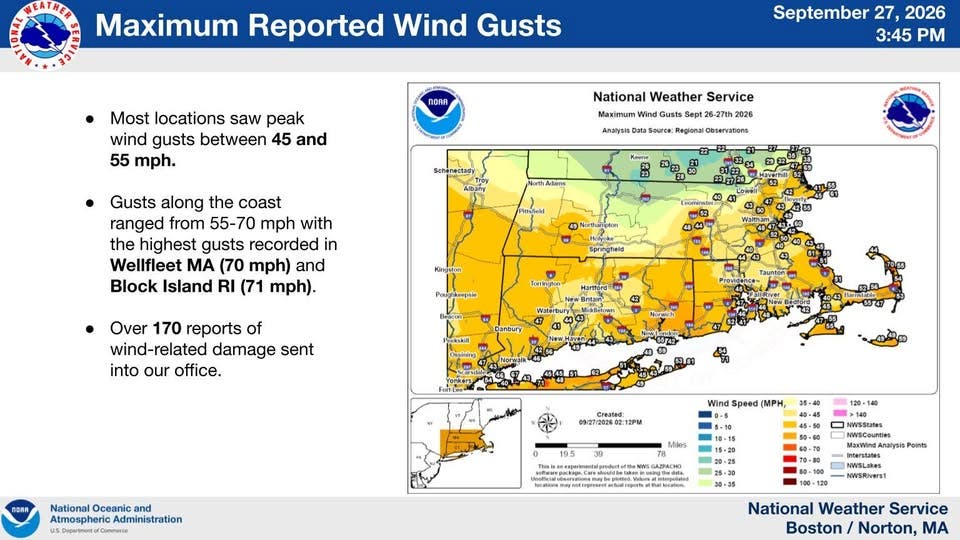
More than 7 inches of rain fell across parts of southeastern MA with top wind gusts near hurricane force on Cape Cod and the Islands.


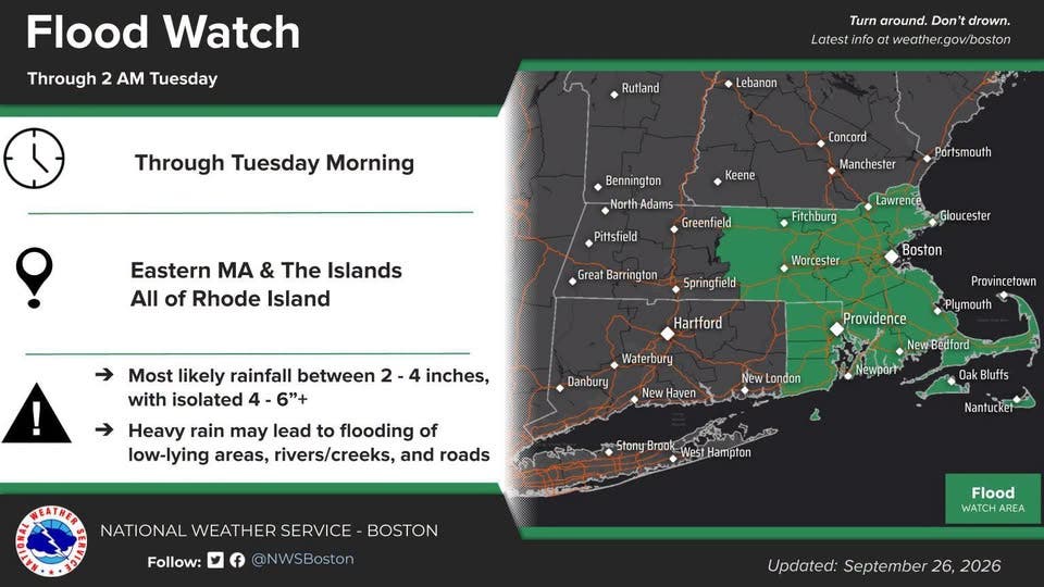
A Flood Watch remained in effect for most of eastern and central Massachusetts on Monday as the region endured the third day of a fall nor'easter that whacked areas with up to 70 mph winds and more than 7 inches of rain over the weekend.
The National Weather Service extended the Flood Watch through Tuesday morning, with highly saturated areas getting up to a half inch more of rain, increasing the risk of downed trees and storm damage. A widespread 2 to 4 inches fell over the first two days of the storm, with some areas approaching 8 inches.
There were more than 170 reports of damage from toppled trees in the wind and rain Saturday and Sunday, according to the NWS. Power outages peaked at about 10,000 on Saturday.
Find out what's happening in Across Massachusettsfor free with the latest updates from Patch.
Top Rainfall Amounts (NWS reports):
- 7.33 inches — Acushnet
- 7.11 inches — Camp Edwards
- 6.99 inches — Randolph
- 6.9 inches — Blue Hills, Canton
- 6.53 inches — West Bridgewater
- 6.47 inches — New Bedford
- 6.31 inches — Carver
- 6.0 inches — Falmouth
- 5.72 inches — Plympton
- 5.69 inches — Westwood
- 5.7 inches — Kingston
- 5.65 inches — Millis
- 5.51 inches — West Tisbury
- 5.42 inches — Taunton
- 5.41 inches — Foxborough
- 5.21 inches — Pembroke
- 5.13 inches — Whitman
- 5.02 inches — Weymouth
- 5.07 inches — Wareham
- 5.0 inches — Milford
Top wind gusts were overnight Friday into Saturday ahead of the storm, with reported gusts hitting 71 mph on Block Island and 70 mph in Wellfleet.
Find out what's happening in Across Massachusettsfor free with the latest updates from Patch.
A Coastal Flood Warning also remained in effect through Monday for the two tide cycles. Splashover and some beach erosion occurred at east-facing and northeast-facing locations during the astronomical high tides of the weekend.
Rain was expected to be intermittent throughout the day on Monday, with the heaviest totals remaining over southeastern Massachusetts and the Cape Cod area already most drenched from the storm.
Areas to the north and west were expected to see drier pockets of air.
Rain was forecast to wind down Monday night into Tuesday morning before the sun returns for a much warmer middle and end of the week.
Latest 7-Day Forecast:
Monday
Showers. Patchy fog. High near 60. Northeast wind 13 to 16 mph. Chance of precipitation is 100%. New precipitation amounts between a quarter and half of an inch possible.
Monday Night
Showers likely, mainly before 2 a.m. Patchy fog. Otherwise, cloudy, with a low around 54. North wind 9 to 11 mph becoming northwest in the evening. Chance of precipitation is 70%. New precipitation amounts between a tenth and quarter of an inch possible.
Tuesday
Patchy fog before 10 a.m. Otherwise, cloudy, with a high near 65. Northwest wind around 11 mph.
Tuesday Night
Mostly cloudy, with a low around 55. Northeast wind 5 to 7 mph becoming calm in the evening.
Wednesday
Partly sunny, with a high near 70. Light and variable wind.
Wednesday Night
Partly cloudy, with a low around 56. Light southwest wind.
Thursday
Mostly sunny, with a high near 77. Southwest wind 5 to 10 mph.
Thursday Night
Partly cloudy, with a low around 64. Southwest wind around 9 mph.
Friday
Mostly sunny, with a high near 76. West wind around 9 mph.
Friday Night
Mostly cloudy, with a low around 56. Northwest wind 5 to 7 mph.
Saturday
Mostly sunny, with a high near 66. North wind 6 to 8 mph.
Saturday Night
Partly cloudy, with a low around 52. North wind 3 to 5 mph.
Sunday
Mostly sunny, with a high near 64. North wind 5 to 9 mph becoming east in the afternoon.
More on Patch:
Get more local news delivered straight to your inbox. Sign up for free Patch newsletters and alerts.