Weather
Major Snowstorm Chances Very High Amid Weekend Bitter Blast Across MA: See Latest Forecast
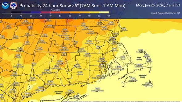
Many spots in Massachusetts have up to a 95 percent chance of 6 inches or more of snow Sunday into Monday.

MASSACHUSETTS — The probability of a moderate to heavy snowstorm is nearing 100 percent in parts of Massachusetts days ahead of a major winter storm that is expected to cause damage and destruction up and down the East Coast this weekend.
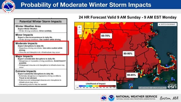
The National Weather Service said on Thursday that the chances of a moderate snowstorm — defined as 6 inches of snow or more — range from 90 to 95 percent in parts of southern Massachusetts and Rhode Island, to 80 to 90 percent across much of Greater Boston, the North Shore and eastern Massachusetts, and 60 to 70 percent in interior Middlesex County and Worcester County.
The storm will bring hazardous driving conditions and significant disruptions to the region just in time for those traveling out to watch the AFC Championship game between the New England Patriots and Denver Broncos at 3 p.m.
Find out what's happening in Across Massachusettsfor free with the latest updates from Patch.
Many of the latest local forecasts on Thursday morning are calling for 12 inches of snow or more during the prolonged storm that will include bouts of heavy snow Sunday afternoon into Sunday night, and the possibility of a second punch of snow on Monday that will rapidly push up accumulations amid freezing temperatures.
If Boston's Logan Airport gets 6 inches of snow or more, it will be the first time in more than four years (1,400+ days) that has happened.
Find out what's happening in Across Massachusettsfor free with the latest updates from Patch.
The snow is only half the weather alert for the weekend as it will be preceded by a dangerous dose of arctic air that will keep highs in the single digits and teens — with wind chills well below zero — from Friday night through the Sunday and Monday storm.
A glimmer of good news comes first on Thursday with temperatures reaching the 40s and allowing for some melting of the one to three inches of snow that fell across parts of the state late Wednesday night.
Things will turn bitter on Friday with sunny skies and a high of 32 degrees that will drop to 5 degrees overnight.
Saturday is bone-chilling despite the sun, with a high of 15 degrees and winds gusting to 28 mph, making it feel like zero or below.
Saturday night is another frigid one with a low of 6 degrees and calming winds.
The snow is expected to arrive late in the morning on Sunday and continue heavy at times in the afternoon into the evening, according to the NWS, with highs sticking in the teens.
A significant "fluff" factor will accompany the snow, given the very low temperatures, increasing snow totals across the region.
Ultimate accumulations will depend on how long the snow lingers into Monday with an extended back end of the storm, or coastal front development, providing the best chance for areas to get between 12 and 18 inches when all is said and done.
The Massachusetts Emergency Management Agency is encouraging residents to start preparing now for the weekend storm.
With a significant snowstorm forecast to affect much of Massachusetts on Sunday and Monday, now is the time to start taking steps to prepare. For more information visit https://t.co/ncHqGL4wWU pic.twitter.com/4oYUfWx5cE
— MEMA (@MassEMA) January 22, 2026
With extremely cold temperatures forecast for this weekend, it's important to take steps to prevent the pipes in your home from freezing. Learn more: https://t.co/Z60ssqeVFh pic.twitter.com/hHyLJbz06g
— MEMA (@MassEMA) January 21, 2026
More on Patch:
Get more local news delivered straight to your inbox. Sign up for free Patch newsletters and alerts.