Weather
New Map Shows Parts Of NJ Likely To Be Impacted By Weekend Winter Storm
An anticipated storm is expected to have an impact on New Jersey this weekend. One track may have people grabbing shovels again.

Forecasters are continuing to monitor another winter storm that's expected to move up the East Coast this weekend, but whether it will bring more snow to New Jersey is still up in the air.
The latest information from the National Weather Service says the storm will be packing strong winds and coastal areas will be dealing with flooding.
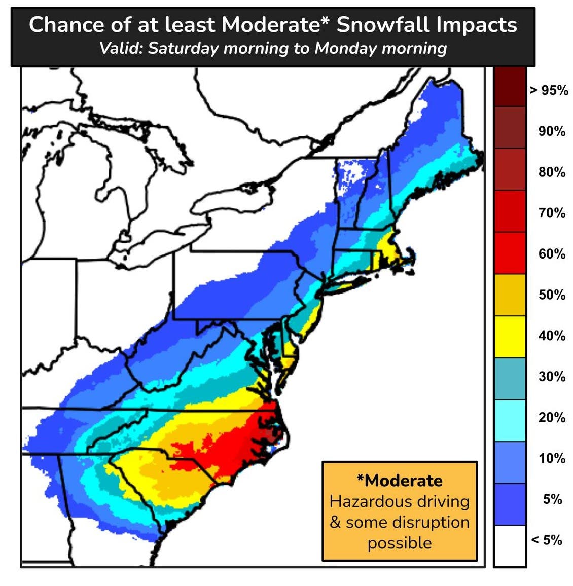
Accuweather was calling the storm a bomb cyclone, and said it could bring the heaviest snow in decades to North Carolina "and a close call with heavy snow along the mid-Atlantic and New England coasts."
Find out what's happening in Across New Jerseyfor free with the latest updates from Patch.
The storm "will rapidly strengthen along the East Coast ... with blizzard conditions likely in the hardest-hit areas," the Accuweather forecast said. It is forecast to be a powerful storm that "will raise winds and seas, leading to significant coastal flooding and beach erosion."
Heavy snow could affect airline travel along the East Coast and could affect travel on Interstate 195, the Accuweather report said.
Find out what's happening in Across New Jerseyfor free with the latest updates from Patch.
In New Jersey, it could mean 3 to 6 inches of snow, depending on the track of the storm, Accuweather said.
Below-freezing temperatures will remain in place across New Jersey into next week, and the cold weather advisory has been extended to 10 a.m. Thursday, the National Weather Service Mount Holly office said, meaning any precipitation that happens will be snow.
The chance for snowfall of 5 inches or more — the level that prompts a winter storm warning — is about 20 to 30 percent for most of the state, according to the service's Weather Prediction Center.
That remains dependent on the track the storm takes, forecasters said.
"Confidence is increasing in a coastal storm developing this weekend, bringing impacts to portions of the area," the National Weather Service Mount Holly office said. "Confidence remains low" on specific impacts beyond strong onshore winds and potential coastal flooding, the forecast said.
"This is still a highly volatile, uncertain forecast because there is still a wide spread of possible storm tracks depicted among model guidance," said meterologist Dan Zarrow of NJ 101.5.
Zarrow said three tracks remain possible, with a coast-hugging track getting the highest probability in his forecast. The chances of a direct hit with heavy snow for the entire state remain slim, he said.
"While it would be foolish to take the 'statewide snow bomb' option completely off the table, that possibility appears unlikely at this point," Zarrow said.
He noted that previous storms this winter have shifted northwest at the last minute, which would mean some snow, especially along the Jersey Shore.
"But I also want to be clear that zero snow is absolutely a possibility here," he said.
Noreaster Nick also said the best chance of snow is farther east, but noted a northwest shift of the storm track is what everyone is watching.
"Does that NW trend that happens 90% of the time peek its little head here? We will know by this afternoon," he said.
The storm is still expected to form Friday in the Gulf and move along the East Coast Saturday into Sunday.
"This strong storm is likely to produce gusty winds," the Weather Prediction Center said. "Where these winds overlap with snowfall, reduced visibility is likely and could make for difficult travel at times.
"Along the Mid-Atlantic coast, increasing onshore winds coincident with astronomical high tieds may lead to periods of coastal flooding and dangerous surf this weekend," the center said.
The Mount Holly office did try to sound a positive note:
"Did you know that, on average, about half of seasonal snowfall in our region occurs before February 4th, with the other half occurring after? Of course, this is an average, and there have been many years where this has turned out to be lopsided, with either most falling before or after February 4th," the Mount Holly office said.
"It's notable since the peak of cold was back on January 21st... the lag is real. Essentially, this means today (1/28) is about the peak of *total winter* (cold plus snow)."
Get more local news delivered straight to your inbox. Sign up for free Patch newsletters and alerts.