Weather
3 Snowfall Predictions For NJ: What Will El Niño Bring
El Niño is strengthening the odds of precipitation across the state, raising the possibility of more storms.


NEW JERSEY — The leaves may still be on the trees and the jack o' lanterns have yet to be lit—but that hasn't stopped the prognosticators from predicting what an El Niño-fueled winter will look like for the Garden State.
An El Niño climate pattern is defined by shifting winds and rainfall patterns across the United States.
The way an El Niño forms is when the surface waters of the central and eastern tropical Pacific Ocean become warmer than usual, kicking off a chain reaction that disrupts typical patterns and lasts through the winter.
Find out what's happening in Across New Jerseyfor free with the latest updates from Patch.
Here are three scenarios laid out by three different weather forecasters.
The Farmer's Almanac
According to The Old Farmer’s Almanac forecast, the best bets for a snowier-than-usual winter are central and southern New England, the Appalachians, the northern Rockies and nearby mountain states, the Pacific Northwest and Alaska. Mountain areas of California and the Southwest could also see near- to above-normal snowfall.
Find out what's happening in Across New Jerseyfor free with the latest updates from Patch.
Other areas could still see plenty of snow, but seasonal totals could finish near or below normal.
And while the Almanac expects temperatures to be mild overall with near- or above-normal temperatures across most of the country, with colder temperatures from central New England through the Appalachians and Ohio Valley. Wetter-than-normal conditions are forecast across much of the West and parts of the South, Midwest and Florida.
The Almanac forecast notes New Jersey falls within the Almanac's "mild, dry" zone for the 2026-27 winter, meaning residents can likely expect near- or above-normal temperatures and below-normal precipitation overall, according to the Almanac's regional forecast map. That puts the state outside the snowier bands the Almanac is projecting farther north and west, including central and southern New England and the Appalachians.
The National Weather Service
Two weeks after the Old Farmer's Almanac shared their outlook, the National Weather Service noted on Sept. 30 that the El Niño climate pattern “supersizing” in the Pacific was driving a new seasonal outlook that offers an early look at how much snow New Jersey could get this winter.
With a greater than 90 percent chance of continuing and a 75 percent probability of reaching historic strength, a powerful El Niño is expected to significantly influence global weather this winter, according to the National Weather Service’s Climate Prediction Center.
Such intense El Niño conditions typically shift the main jet stream, channeling abundant tropical moisture across the southern United States and driving active storm tracks north along the Atlantic Seaboard.
The new seasonal outlook for December, January and February reflects a classic strong El Niño pattern.
In New Jersey, expect a 40 to 50 percent chance of above-normal temperatures and precipitation.
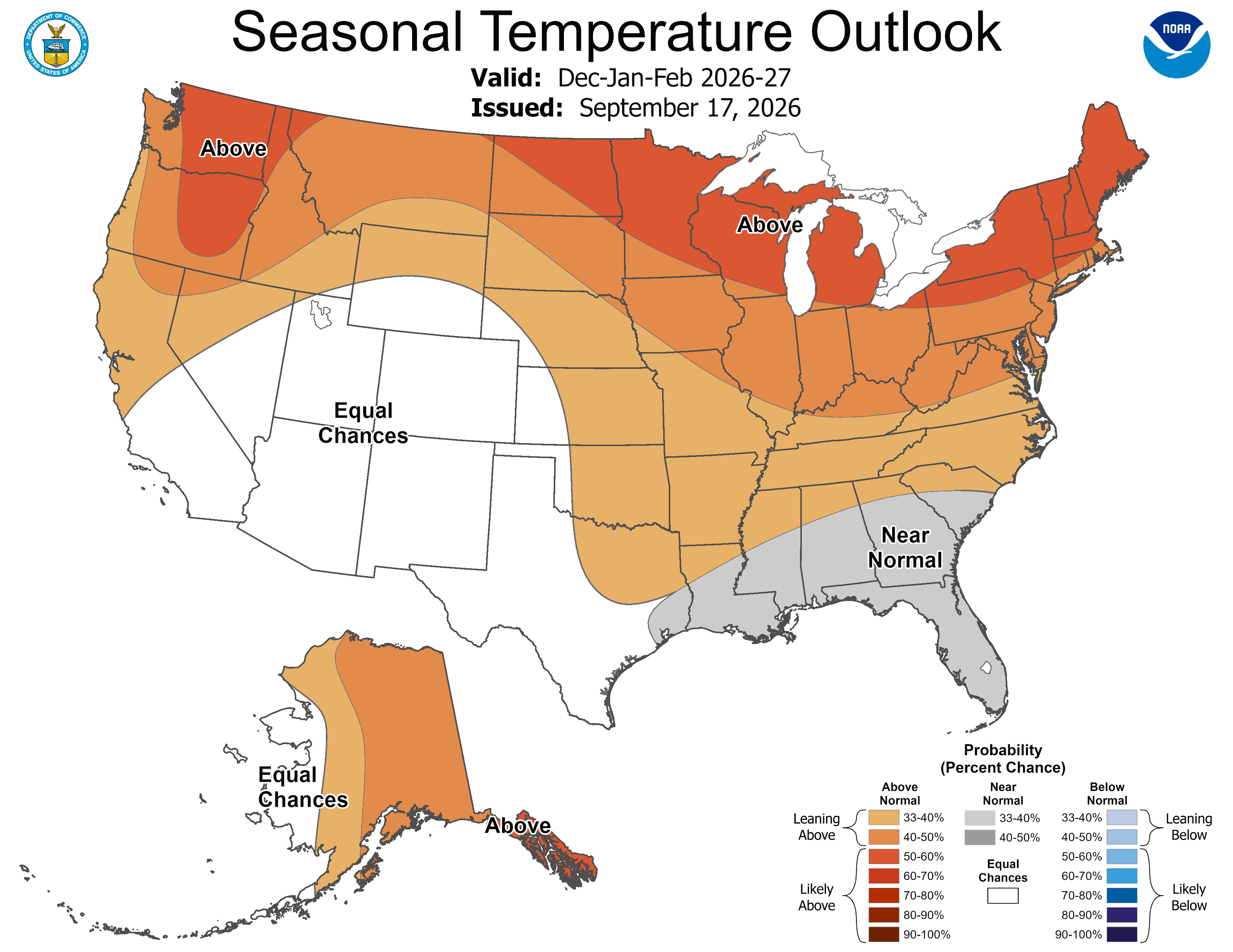
The Northeast also generally leans warmer than normal, with wetter conditions favored in some areas along the East Coast.
Accuweather
The meteorologists at Accuweather have been watching El Niño strengthen for months, and their latest in a round of 2026-27 winter forecasts confirms what others have said about the potentially record-setting climate pattern.
"This has the potential to be the strongest El Niño on record," AccuWeather Long-Range Expert Paul Pastelok said, noting it is "almost certain" to surpass the powerful El Niños of 1982-83 and 1997-98.
El Niño is expected to rearrange storm tracks across the country, generally favoring a more active southern storm track while bringing warmer conditions and less snow to large parts of the northern United States, AccuWeather said in its new 2026-27 winter forecast released in early October.
The broad pattern is consistent with what federal forecasters have been watching for months. The National Oceanic and Atmospheric Administration said in September that El Niño was strengthening, with a greater than 90 percent chance it would become a very strong event during the fall and winter. NOAA put the chance of a historically strong El Niño during October through December at 75 percent.
That does not mean every week of winter will follow the script. Cold outbreaks and major snowstorms can still occur in areas expected to finish the season warmer or less snowy than average.
The National Weather Service’s next El Niño briefing is on Nov. 19. Stay tuned for updates on Patch.
Get more local news delivered straight to your inbox. Sign up for free Patch newsletters and alerts.