Weather
Freezing Rain Concerns Grow For Hudson Valley: Timeline, New Details Released
Find out the latest forecast for wintry weather and the weekend outlook, according to meteorologists.

HUDSON VALLEY, NY — Wintry precipitation is expected to impact portions of the Hudson Valley tonight, which could lead to slippery conditions for the Friday morning commute, according to meteorologists.
The National Weather Service’s Albany office reports rain will transition to a wintry mix of freezing rain and sleet tonight.
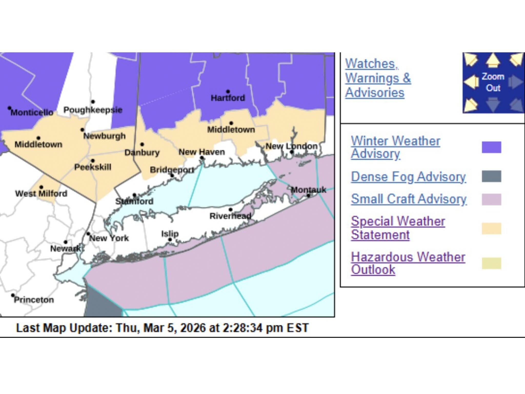
“There is a 20-40% chance of at least 0.10" flat ice in lower elevations and a 50-80% chance in higher elevations,” the National Weather Service said Thursday. “There is a 20-60% chance of at least 0.25" flat ice in higher elevations. Untreated surfaces will become icy.”
Find out what's happening in Mid Hudson Valleyfor free with the latest updates from Patch.
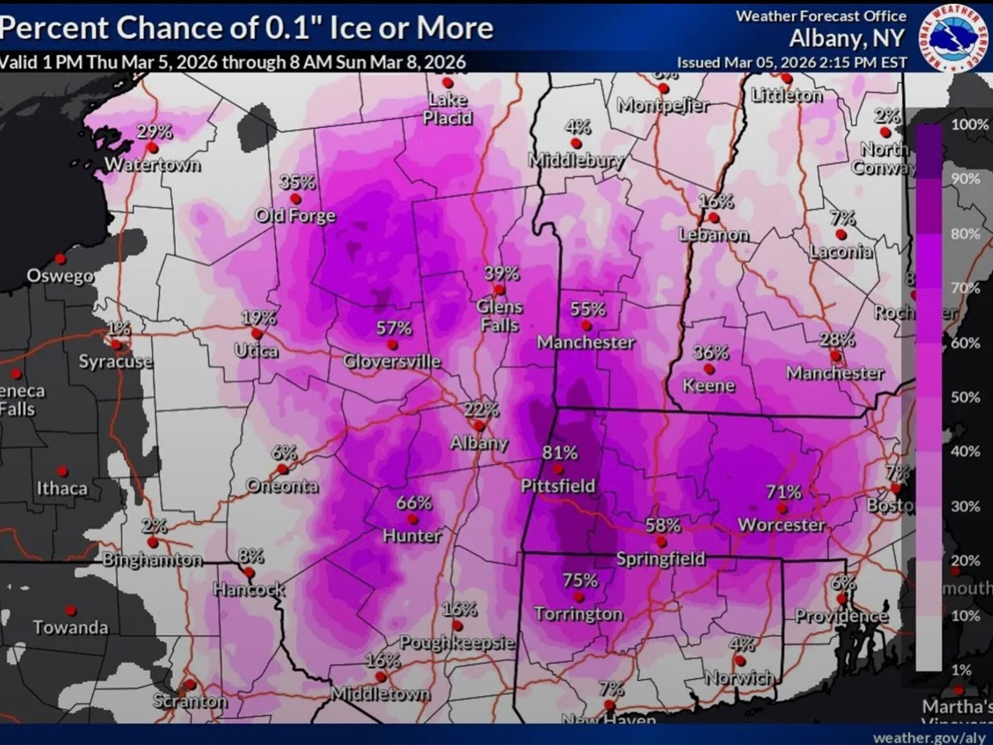
The National Weather Service’s New York office issued a special weather statement Thursday afternoon for Orange, Putnam and Rockland counties, and northern Westchester County.
It advises there will be possible pockets of freezing rain overnight and into Friday morning.
Find out what's happening in Mid Hudson Valleyfor free with the latest updates from Patch.
“As rain continues to fall tonight into Friday morning, temperatures are expected to lower to near the freezing mark. Localized icy conditions could develop, and motorists and pedestrians are advised to use extra caution if traveling tonight or early Friday morning,” the statement said.
The weekend is looking to be much warmer, with daytime high temperatures reaching into the 50s throughout the region on Saturday and Sunday.
Here are the forecast details for the Mid-Hudson Valley area via the National Weather Service:
Tonight: Rain, mainly before 4 a.m. Low around 34. North wind 3 to 5 mph. Chance of precipitation is 100%. New precipitation amounts between a half and three quarters of an inch possible.
Friday: A chance of rain, mainly before 7 a.m. Cloudy, with a high near 42. North wind around 5 mph becoming calm in the morning. Chance of precipitation is 30%. New precipitation amounts of less than a tenth of an inch possible.
Friday Night: A slight chance of rain after 1 a.m. Cloudy, with a low around 34. Calm wind. Chance of precipitation is 20%.
Saturday: Mostly cloudy, with a high near 51. South wind 3 to 7 mph.
Saturday Night: Rain likely, mainly before 1am. Cloudy, with a low around 45. Chance of precipitation is 70%. New precipitation amounts of less than a tenth of an inch possible.
Sunday: Mostly sunny, with a high near 57.
Here are the forecast details for the lower Hudson Valley area via the National Weather Service:
Tonight: Rain, mainly before 4 a.m. Low around 35. Northeast wind around 11 mph, with gusts as high as 23 mph. Chance of precipitation is 100%. New precipitation amounts between a half and three quarters of an inch possible.
Friday: A 20 percent chance of rain before 10 a.m. Cloudy, with a high near 42. Northeast wind 6 to 9 mph.
Friday Night: A 30 percent chance of rain after 1 a.m. Patchy fog. Otherwise, cloudy, with a low around 35. Northeast wind around 5 mph becoming calm after midnight.
Saturday: Cloudy, with a high near 51. Calm wind becoming south 5 to 7 mph in the morning.
Saturday Night: Rain. Temperature rising to around 52 by 4 a.m. Chance of precipitation is 80%. New precipitation amounts of less than a tenth of an inch possible.
Sunday: Cloudy, then gradually becoming mostly sunny, with a high near 59.
Get more local news delivered straight to your inbox. Sign up for free Patch newsletters and alerts.