Weather
Snow Accumulation Estimates Released For Next Storm In Hudson Valley
Find out the latest timeline for the next round of snow.

HUDSON VALLEY, NY — After today’s dry and sunny weather, the Hudson Valley region is expected to get more snow on Wednesday.
The National Weather Service said a light snowfall is expected to start before sunrise and last into late Wednesday morning.
Its New York City office predicts between one and two inches of snow will fall in the lower Hudson Valley area.
Find out what's happening in Mid Hudson Valleyfor free with the latest updates from Patch.
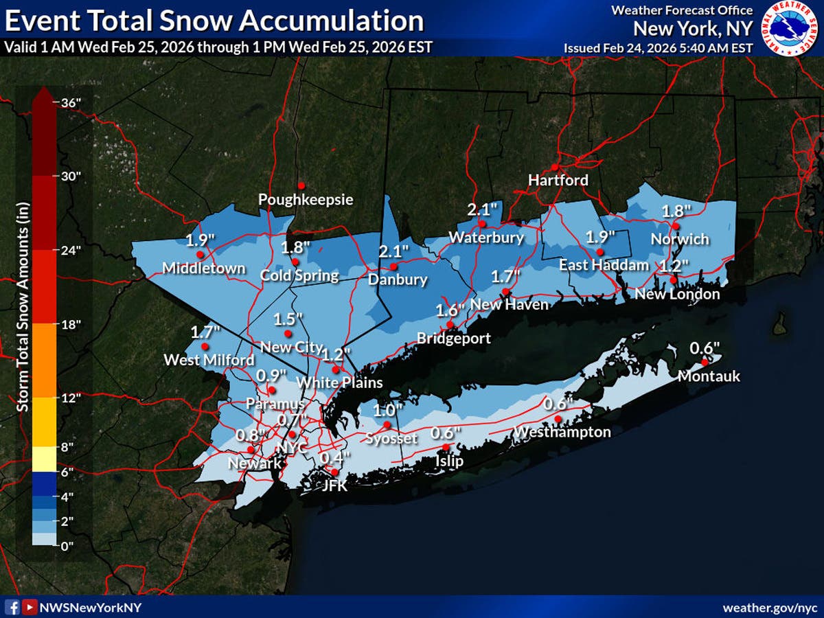
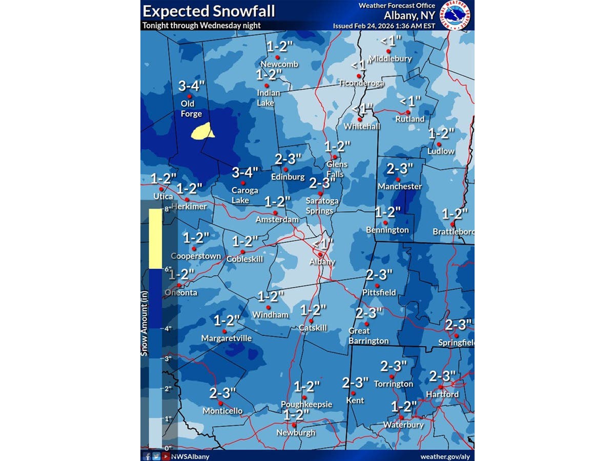
According to the National Weather Service’s Albany office, which does forecasts for northern parts of the Hudson Valley region, a clipper low will bring “light to moderate snowfall” with widespread accumulations of between one and three inches.
The National Weather Service predicts the snow will begin between 3 a.m. and 4 a.m. on Wednesday and end by around 10 a.m.
Find out what's happening in Mid Hudson Valleyfor free with the latest updates from Patch.
There is another chance of snow on Thursday, then Friday through Sunday are expected to be dry and warmer, with weekend high temperatures reaching into the 40s, according to the National Weather Service.
Here are the forecast details for the Mid-Hudson Valley area via the National Weather Service:
This Afternoon: Mostly sunny, with a high near 29. West wind around 6 mph.
Tonight: Snow, mainly after 3 a.m. Low around 12. Light and variable wind. Chance of precipitation is 80%. New snow accumulation of around an inch possible.
Wednesday: Snow likely, mainly before 10 a.m. Mostly cloudy, with a high near 41. South wind 6 to 9 mph. Chance of precipitation is 70%. New snow accumulation of less than one inch possible.
Wednesday Night: Partly cloudy, with a low around 24. South wind around 6 mph becoming light and variable after midnight.
Thursday: A slight chance of snow after 1 p.m. Mostly sunny, with a high near 38. Light west wind. Chance of precipitation is 20%.
Thursday Night: A slight chance of snow. Partly cloudy, with a low around 18. Chance of precipitation is 20%.
Friday: Mostly sunny, with a high near 39.
Friday Night: Partly cloudy, with a low around 23.
Saturday: Mostly sunny, with a high near 48.
Saturday Night: Partly cloudy, with a low around 27.
Sunday: Partly sunny, with a high near 38.
Here are the forecast details for the lower Hudson Valley area via the National Weather Service:
This Afternoon: Mostly sunny, with a high near 31. Wind chill values between 15 and 20. Blustery, with a northwest wind 15 to 20 mph, with gusts as high as 30 mph.
Tonight: Snow after 4 a.m. Low around 17. West wind 5 to 7 mph becoming calm. Chance of precipitation is 80%. New snow accumulation of around an inch possible.
Wednesday: Snow before 10 a.m. High near 39. Wind chill values between 20 and 30. Southwest wind around 10 mph, with gusts as high as 20 mph. Chance of precipitation is 80%. New snow accumulation of less than one inch possible.
Wednesday Night: Partly cloudy, with a low around 28. West wind around 8 mph.
Thursday: A 30 percent chance of snow, mainly after 4 p.m. Partly sunny, with a high near 37. West wind around 6 mph.
Thursday Night: A 40 percent chance of snow before 4 a.m. Mostly cloudy, with a low around 24.
Friday: Mostly sunny, with a high near 37.
Friday Night: Partly cloudy, with a low around 27.
Saturday: Mostly sunny, with a high near 43.
Saturday Night: Partly cloudy, with a low around 29.
Sunday: Partly sunny, with a high near 40.
Get more local news delivered straight to your inbox. Sign up for free Patch newsletters and alerts.