Weather
Snow, Ice, Rain Predicted To Fall In Hudson Valley: NWS
Find out when to expect wintry weather and what the long-term forecast looks like, according to meteorologists.

HUDSON VALLEY, NY — Winter weather advisories are in effect for portions of the Hudson Valley today.
Wintry weather is expected to ramp up around mid-day today and end early Wednesday, according to the National Weather Service.
Mixed precipitation is expected, with total snow and sleet accumulations of up to two inches and ice accumulations up to one tenth of an inch, the National Weather Service reports.
Find out what's happening in Mid Hudson Valleyfor free with the latest updates from Patch.
As for timing, it anticipates light snow will overspread the region this afternoon, before it mixes with sleet and freezing rain later this afternoon and into this evening. The precipitation is expected to taper off overnight, according to the advisory.
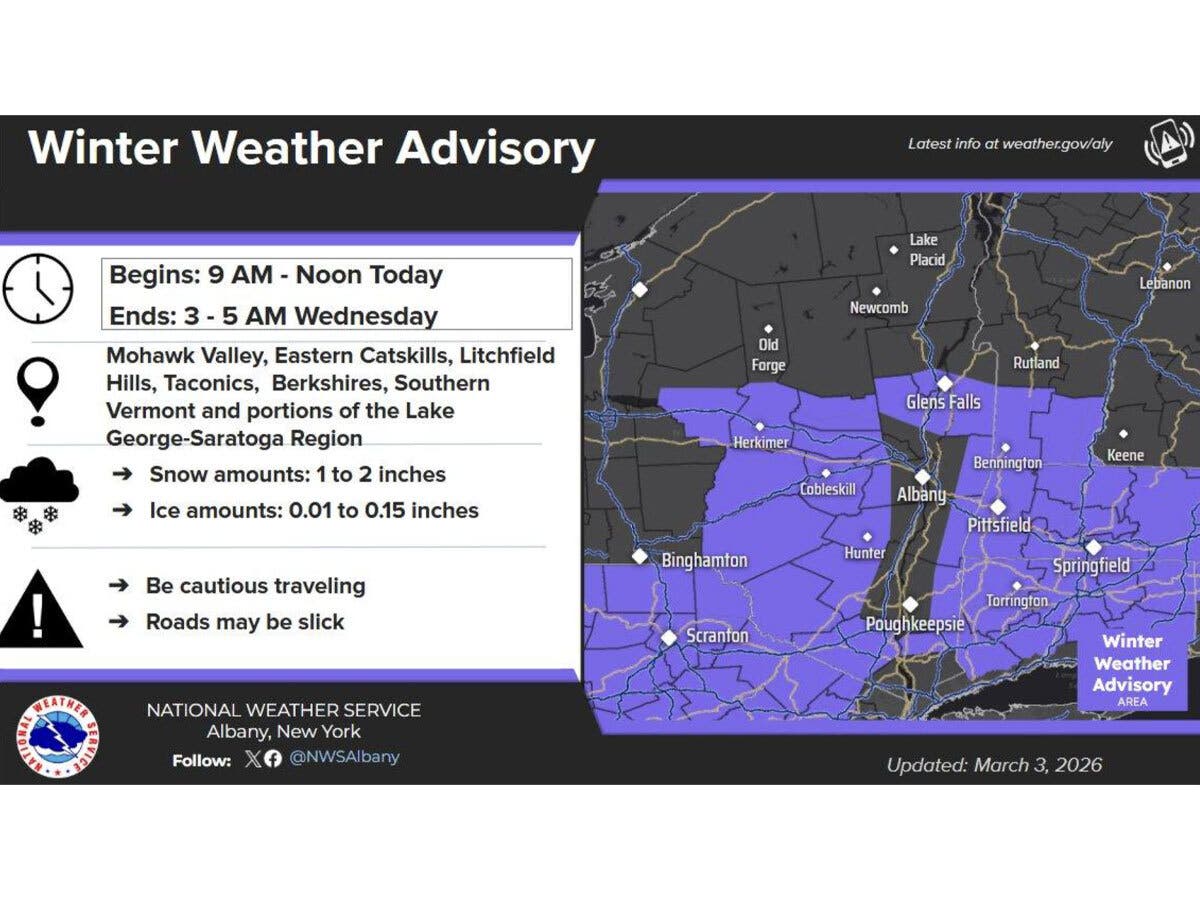
The National Weather Service’s Albany office advises that “low pressure system moving along a frontal boundary south of the region will bring snow and a wintry mix to portions of eastern NY and western New England mainly this afternoon into early tonight.”
Find out what's happening in Mid Hudson Valleyfor free with the latest updates from Patch.
It predicts snowfall amounts of between one and two inches, with a light glaze possible.
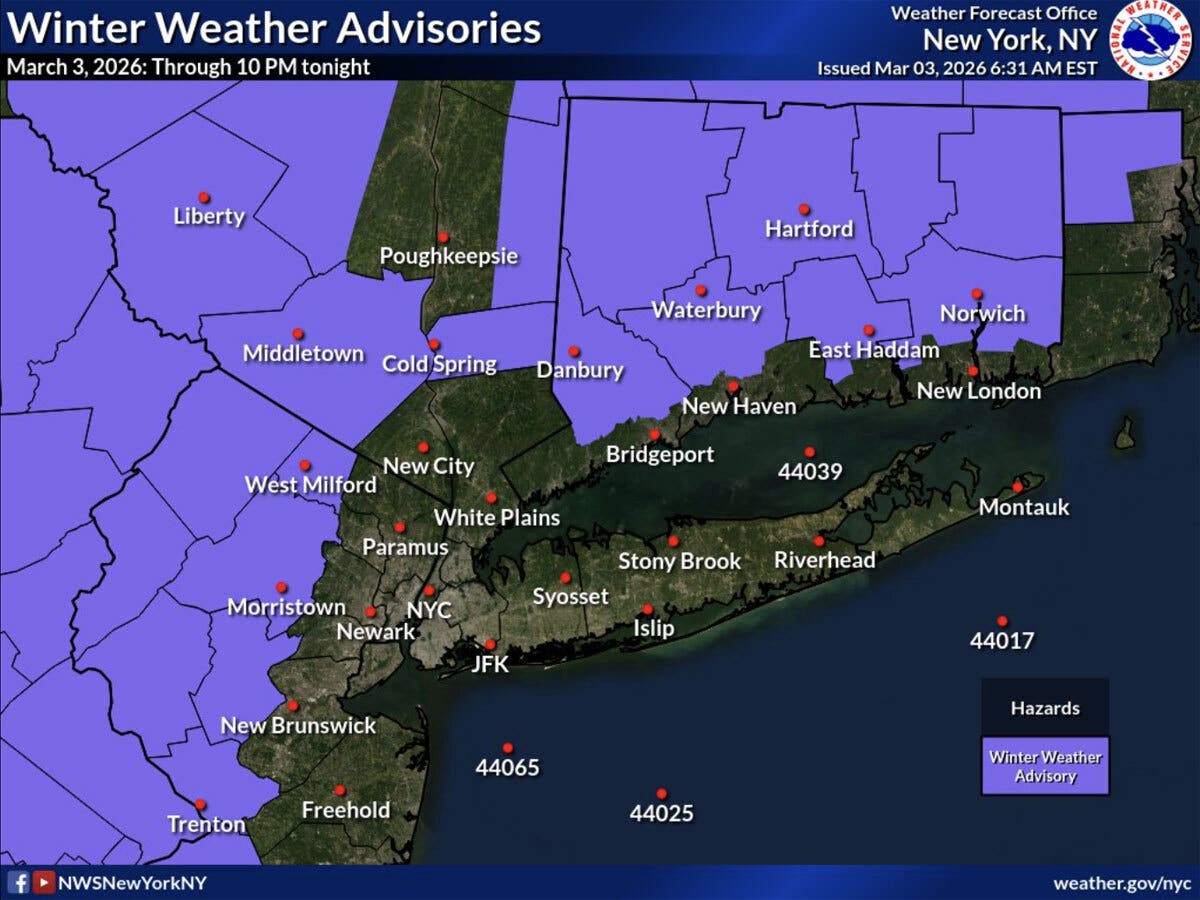
The National Weather Service’s New York office on Tuesday indicated that winter weather advisories have been expanded to portions of the lower Hudson Valley through 10 p.m. tonight.
“These advisories are for a light glaze of ice and snow accumulations of less than an inch,” the National Weather Service said. “Take precautions if traveling today.”
For southernmost portions of the Hudson Valley, the forecast is for rain, possibly mixed with snow, becoming all rain by mid-afternoon. The rain is expected to continue throughout the evening, then taper off after midnight, according to the National Weather Service.
Looking ahead, warmer weather is in the forecast, with high temperatures in the mid to upper 40s for Wednesday through Friday. On Saturday and Sunday, it will be even warmer, with highs around 60 expected, forecasters said.
Here are the forecast details for the Mid-Hudson Valley area via the National Weather Service:
Today: Snow before 4 p.m., then snow, possibly mixed with sleet. High near 32. Light south wind. Chance of precipitation is 90%. Total daytime snow and sleet accumulation of less than one inch possible.
Tonight: Rain and freezing rain, possibly mixed with sleet before 2 a.m., then a slight chance of rain between 2 a.m. and 3 a.m. Low around 31. Calm wind. Chance of precipitation is 90%. New ice accumulation of less than a 0.1 of an inch possible. New sleet accumulation of less than a half inch possible.
Wednesday: Mostly sunny, with a high near 49. Calm wind.
Wednesday Night: A chance of showers after 1 a.m. Mostly cloudy, with a low around 31. Calm wind. Chance of precipitation is 30%. New precipitation amounts of less than a tenth of an inch possible.
Thursday: Showers likely, mainly after 1 p.m. Cloudy, with a high near 46. Light northeast wind. Chance of precipitation is 60%. New precipitation amounts between a tenth and quarter of an inch possible.
Thursday Night: Showers. Low around 37. Chance of precipitation is 90%. New precipitation amounts between a half and three quarters of an inch possible.
Friday: A chance of showers before 1 p.m. Mostly cloudy, with a high near 44. Chance of precipitation is 40%.
Friday Night: Cloudy, with a low around 36.
Saturday: Mostly cloudy, with a high near 59.
Saturday Night: Rain likely, mainly before 1 a.m. Mostly cloudy, with a low around 45. Chance of precipitation is 60%.
Sunday: Partly sunny, with a high near 62.
Here are the forecast details for the lower Hudson Valley area via the National Weather Service:
Today: Rain, possibly mixed with snow, becoming all rain after 3 p.m. High near 37. Wind chill values between 25 and 30. East wind 5 to 7 mph. Chance of precipitation is 100%. Total daytime snow accumulation of less than a half inch possible.
Tonight: Rain, mainly before 1 a.m. Low around 34. Light and variable wind becoming southwest around 6 mph in the evening. Chance of precipitation is 100%. New precipitation amounts between a quarter and half of an inch possible.
Wednesday: Partly sunny, with a high near 48. Light and variable wind.
Wednesday Night: A 30 percent chance of rain after 1 a.m. Mostly cloudy, with a low around 35. Calm wind.
Thursday: Rain likely, mainly before 1 p.m. Cloudy, with a high near 45. Calm wind becoming northeast around 6 mph in the afternoon. Chance of precipitation is 60%. New precipitation amounts between a tenth and quarter of an inch possible.
Thursday Night: Rain likely. Cloudy, with a low around 38. Chance of precipitation is 70%. New precipitation amounts between a quarter and half of an inch possible.
Friday: A 40 percent chance of rain before 1 p.m. Mostly cloudy, with a high near 46.
Friday Night: Cloudy, with a low around 37.
Saturday: Mostly cloudy, with a high near 55.
Saturday Night: Rain likely, mainly before 1 a.m. Mostly cloudy, with a low around 47. Chance of precipitation is 60%.
Sunday: Mostly cloudy, with a high near 62.
Get more local news delivered straight to your inbox. Sign up for free Patch newsletters and alerts.