Weather
Thunderstorms, Temperature Changes Emerge In Hudson Valley Forecast
Find out the latest timeline for possible wet weather and the latest weekend forecast.


HUDSON VALLEY, NY — It will be hot and muggy in the Hudson Valley today, with the chance for isolated showers and thunderstorms after 3 p.m., according to the National Weather Service.
High temperatures are expected to reach between 84 and 88 degrees in the region today, with mostly cloudy skies, forecasters said.
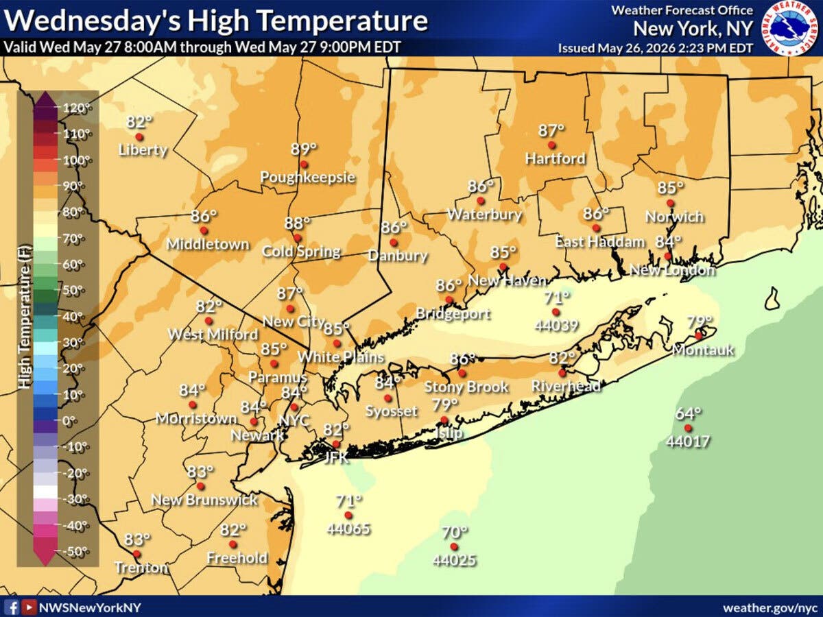
After today, changes are coming, with more comfortable and pleasant weather in the forecast.
Find out what's happening in Mid Hudson Valleyfor free with the latest updates from Patch.
“A cold front tracking through the region Wednesday will see temperatures drop back towards normal levels by Thursday and Friday. In other words, it's gonna be beautiful! Enjoy!” the National Weather Service said.
Both Thursday and Friday are expected to be mostly sunny, with highs around 77 degrees, the National Weather Service predicts.
Find out what's happening in Mid Hudson Valleyfor free with the latest updates from Patch.
The end of the workweek brings another chance of precipitation, with a 30 percent chance of showers Friday night, and those showers could linger into early Saturday, meteorologists said.
The weekend forecast is looking pleasant, with mostly sunny skies both Saturday and Sunday, and daytime highs around 72 degrees, according to the National Weather Service.
Here are the forecast details for the Mid-Hudson Valley area via the National Weather Service:
Today: Isolated showers and thunderstorms after 3 p.m. Partly sunny, with a high near 88. West wind 5 to 8 mph. Chance of precipitation is 20%.
Tonight: Partly cloudy, with a low around 57. North wind 3 to 6 mph.
Thursday: Mostly sunny, with a high near 77. North wind 6 to 11 mph, with gusts as high as 23 mph.
Thursday Night: Mostly clear, with a low around 51. North wind 5 to 7 mph becoming calm in the evening.
Friday: Mostly sunny, with a high near 77. Calm wind becoming west 5 to 7 mph in the afternoon.
Friday Night: A chance of showers. Mostly cloudy, with a low around 54. Chance of precipitation is 30%. New precipitation amounts of less than a tenth of an inch possible.
Saturday: Mostly sunny, with a high near 69.
Saturday Night: Mostly clear, with a low around 48.
Sunday: Mostly sunny, with a high near 73.
Here are the forecast details for the lower Hudson Valley area via the National Weather Service:
Today: A 30 percent chance of showers, mainly between 2 p.m. and 5 p.m. Mostly cloudy, with a high near 84. West wind 9 to 11 mph.
Tonight: Partly cloudy, with a low around 61. Northwest wind around 8 mph.
Thursday: Sunny, with a high near 76. North wind 8 to 14 mph.
Thursday Night: Mostly clear, with a low around 55. North wind 6 to 9 mph.
Friday: Mostly sunny, with a high near 78. West wind 6 to 10 mph.
Friday Night: A 30 percent chance of showers after 2 a.m. Mostly cloudy, with a low around 57.
Saturday: A 30 percent chance of showers before 8 a.m. Mostly sunny, with a high near 72.
Saturday Night: Mostly clear, with a low around 50.
Sunday: Sunny, with a high near 72.
Get more local news delivered straight to your inbox. Sign up for free Patch newsletters and alerts.