Weather
NC Weather Alert: Tropical Storm Warning In Effect For Coast
On Saturday night, Tropical Storm Arthur became the first named storm of the 2020 Atlantic hurricane season. See how it will impact NC.

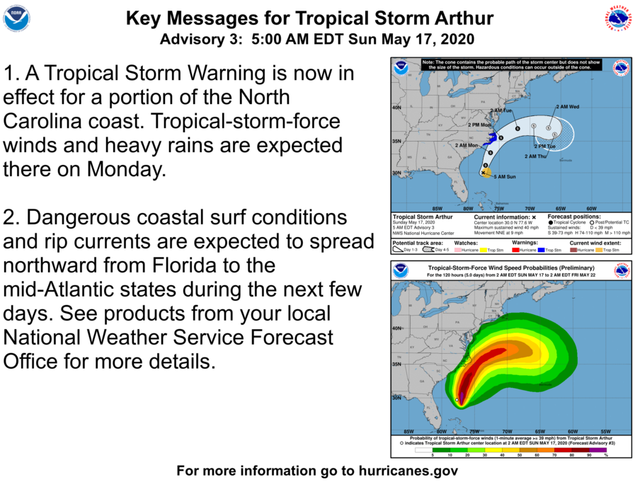
NORTH CAROLINA — As Tropical Storm Arthur became the first named storm of the 2020 Atlantic hurricane season Saturday, a tropical storm warning was issued for the coast of North Carolina.
The National Hurricane Center warned of possible life-threatening surf and rip current conditions across much of the U.S. southeast and mid-Atlantic coasts late Saturday night.
Arthur was packing sustained winds near 40 mph early Sunday morning, just over the 39 mph threshold to be considered a tropical storm. Peak wind forecast is set for 15-25 mph with gusts to 40 mph, but potential for wind 39 to 57 mph.
Find out what's happening in Across North Carolinafor free with the latest updates from Patch.
"Arthur is moving toward the north-northeast near 13 mph and this general motion is expected to continue today," the National Hurricane Center said early Sunday. "A faster northeastward motion is expected on Monday."
Find out what's happening in Across North Carolinafor free with the latest updates from Patch.
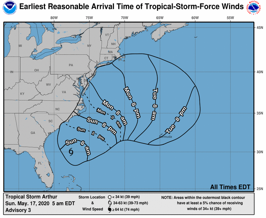
A tropical storm watch was in effect for Surf City to Duck, North Carolina and from Pamlico and Albermarle Sounds.
A tropical storm warning means tropical storm-force winds are expected somewhere within this area within the next 36 hours.
The National Hurricane Center said Arthur is expected to stay offshore, but will still produce strong winds.
"On the forecast track, Arthur will remain well offshore the east coast of Florida, Georgia and South Carolina today, and then move near or east of the coast of North Carolina on Monday," forecasters said.
The system was expected to produce rain accumulations of 1 to 2 inches over coastal North Carolina on Sunday night and Monday.
"Swells generated by Arthur are affecting portions of the east coast of central and northern Florida," the National Hurricane Center said. "These swells are expected to spread northward during the next few days, and could cause life-threatening surf and rip current conditions across much of the U.S. southeast and mid-Atlantic coasts."
Portions of the adjacent Atlantic coastal waters, Albemarle, Croatan and Roanoke and Pamlico Sounds and Alligator, Neuse and Bay and Pamlico and Pungo Rivers, will also be effected.
The warning is in effect through late Sunday night into Monday afternoon. The National Hurricane Center warns of strong winds that will cause hazardous seas and which could capsize or damage vessels and reduce visibility.
Tornadoes are not expected, however, showers and thunderstorms with gusty winds may still occur.
The Atlantic hurricane season runs through Nov. 30. It is not uncommon to have named storms prior to the official start of the season.
This year's list of Atlantic storm names includes Arthur, Bertha, Cristobal, Dolly, Edouard, Fay, Gonzalo, Hanna, Isaias, Josephine, Kyle, Laura, Marco, Nana, Omar, Paulette, Rene, Sally, Teddy, Vicky and Wilfred.
The Atlantic basin includes the Atlantic Ocean, Caribbean Sea and Gulf of Mexico. The National Oceanic and Atmospheric Administration Climate Prediction Center will issue its outlook for the Atlantic and eastern North Pacific basins on May 21, just ahead of the official start of the Atlantic hurricane season.
Patch Editor Paul Scicchitano contributed to this article.
Get more local news delivered straight to your inbox. Sign up for free Patch newsletters and alerts.