Weather
104 Degree Temps Coming To Philly Area In Dangerous Heat Wave: Forecast, Timing
An extreme heat wave could bring several consecutive days of brutal and dangerous conditions to the Philadelphia area.

A dangerous extreme heat wave looms over the Philadelphia area this week as the region braces for the consequences of the "heat dome" effect, according to forecasters.
Temperatures will be fairly typical Monday and Tuesday before a stultifying combination of lingering humidity and heat sets in on Wednesday.
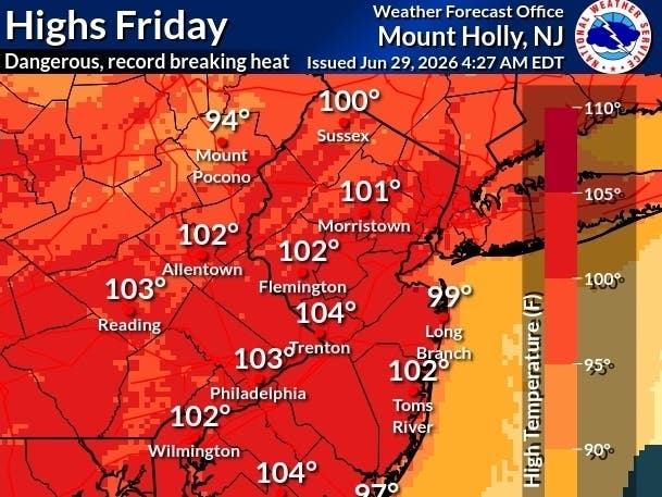
Highs will range from 95 to 105 degrees from Wednesday through Saturday, with the hottest days likely Friday and Saturday, which is Fourth of July.
Find out what's happening in Across Pennsylvaniafor free with the latest updates from Patch.
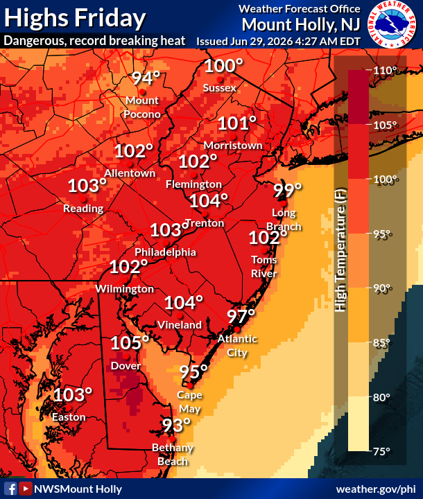
"Very warm low temperatures in the mid 70s to low 80s at night will not offer any relief from the heat," the National Weather Service's Mt. Holly, New Jersey branch shared."This combined with multiple days of near record breaking temperatures will exacerbate the impacts from the heat and humidity."
Some thunderstorms could offer some relief for a brief period in the afternoons on Friday, Saturday, and Sunday, but it's not yet clear how likely those storms are to hit.
Find out what's happening in Across Pennsylvaniafor free with the latest updates from Patch.
"People who mind the heat will be very uncomfortable if they don't have air conditioning," Accuweather Meteorologist Alex Duffus said.
Heat domes occur when a massive area of high pressure, in this case covering huge swaths of the eastern half of the country, prevent clouds from forming. That intensifies temperatures while keeping humidity high for longer periods that normal.
The accumulation of several days of severe temperatures increases the possibility of heat-related illness, the National Weather Service says. That's particularly true during a long holiday weekend with numerous activities planned outdoors.
It could be even worse in the city and the densest suburban areas.
"Urban areas retain heat because pavement, concrete and brick absorb solar energy during the day and release it slowly overnight," Accuweather added. "The long daylight hours of late June and July amplify this urban heat island effect."
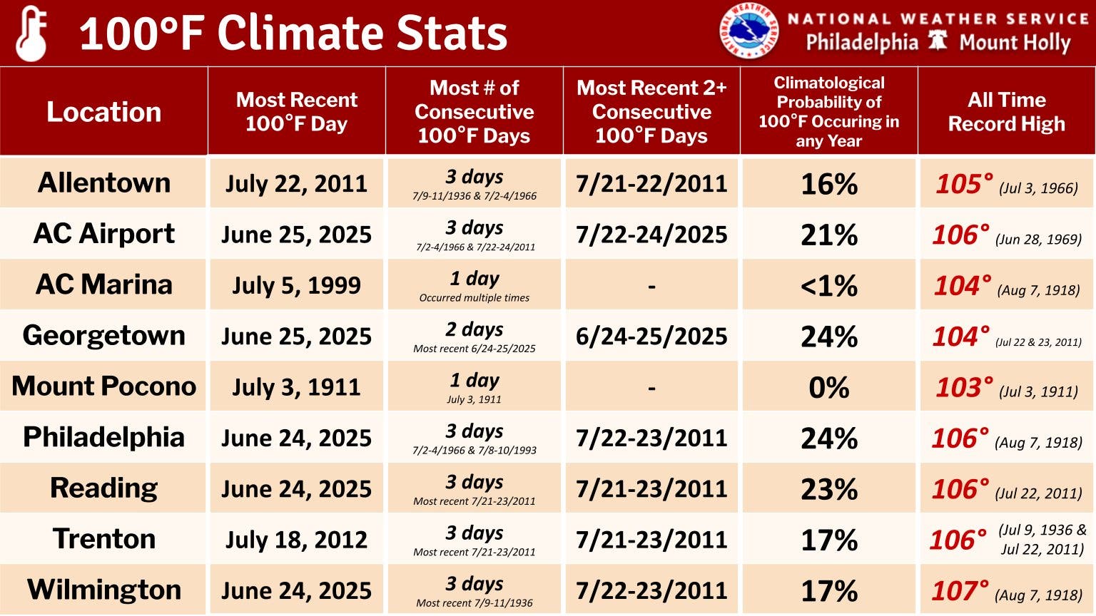
Philadelphia and most of the region have not seen consecutive 100 degree-plus days since 2011, officials said.
Here's the full forecast for the coming week:
Monday
Mostly sunny, with a high near 88. Calm wind becoming northeast around 5 mph.
Monday Night
Mostly clear, with a low around 67. South wind around 5 mph becoming calm in the evening.
Tuesday
Sunny, with a high near 89. Light southwest wind increasing to 5 to 10 mph in the morning.
Tuesday Night
A slight chance of showers and thunderstorms before 2 a.m. Mostly clear, with a low around 71. South wind 5 to 10 mph. Chance of precipitation is 20 percent.
Wednesday
Sunny and hot, with a high near 97. Southwest wind around 10 mph.
Wednesday Night
Mostly clear, with a low around 79.
Thursday
Sunny and hot, with a high near 102.
Thursday Night
Clear, with a low around 80.
Friday
Sunny and hot, with a high near 103.
Friday Night
A chance of showers and thunderstorms between 8 p.m. and 2 a.m. Partly cloudy, with a low around 80. Chance of precipitation is 30 percent.
Fourth of July
A chance of showers and thunderstorms. Mostly sunny and hot, with a high near 99. Chance of precipitation is 40 percent.
Saturday Night
A chance of showers and thunderstorms. Mostly cloudy, with a low around 77. Chance of precipitation is 50 percent.
Sunday
A chance of showers and thunderstorms. Mostly sunny, with a high near 95. Chance of precipitation is 40 percent.
Get more local news delivered straight to your inbox. Sign up for free Patch newsletters and alerts.


