Weather
Major Weather Shift For Eastern PA, Temps Could Drop By 50 Degrees: See Timing
Record heat could be replaced by record cold in the coming days.

A dramatic temperature shift of more than 40 degrees in the coming days is in the forecast for the Philadelphia area, forecasters said, as record April heat could be replaced with record cold and heavy rain.
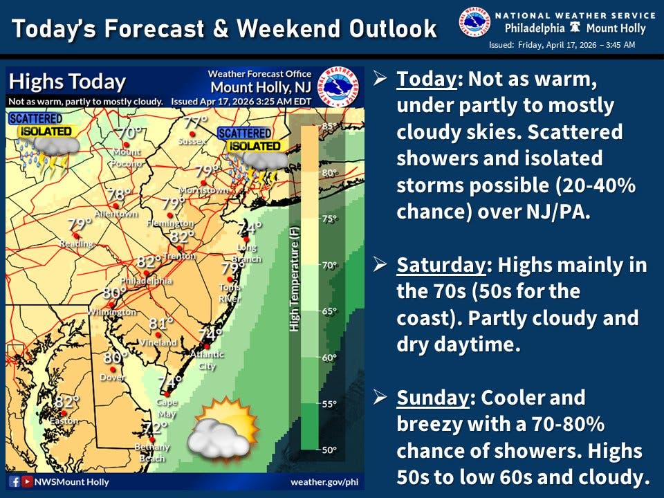
Temperatures will remain in the 80s Friday, with some showers possible Friday night and Saturday night. A cold weather front on Sunday will cause the most significant change, with up to a quarter inch of rain falling and thunderstorms threatening throughout the day. The high will barely break 60.
Sunday night, low temperatures around the Philadelphia area could drop into the upper 30s.
Find out what's happening in Across Pennsylvaniafor free with the latest updates from Patch.
The aggressive pendulum swing may have significant ecological consequences.
"A temperature drop of 30-50 degrees or more can have real consequences for crops and early blooms," Accuweather Senior Meteorologist Tyler Roys said Thursday. "Warmth has accelerated budding, and now a sudden frost or freeze could damage or even wipe out sensitive vegetation."
Find out what's happening in Across Pennsylvaniafor free with the latest updates from Patch.
Trees, vines, and bushes, which had buds break through due to the warmth, could be heavily damaged by the freeze.
Monday will be even colder, with a high of just 53 and a low of 34. The dial will then be turned up once again, with temperatures gradually rising into the 70s again by later next week.
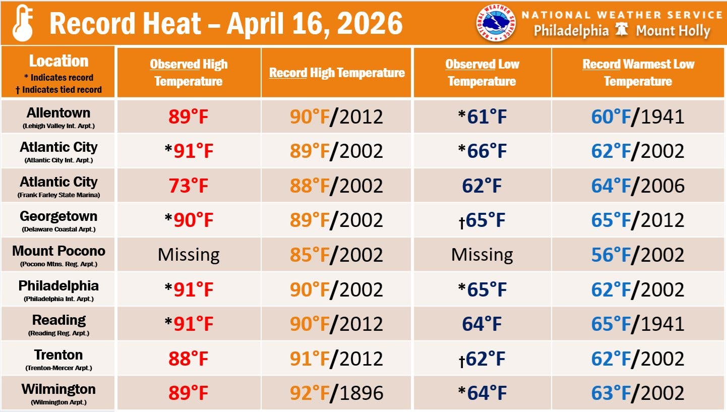
The abrupt change in the forecast comes after Philadelphia, Reading, and other outlying suburbs snapped all time heat records on Thursday. Philadelphia's high of 91 broke a 24-year-old mark.
Here's the full forecast for the coming week in the Philadelphia area, according to the National Weather Service:
Friday
Scattered showers between 2 p.m. and 3 p.m., then scattered showers and thunderstorms after 3 p.m. Partly sunny, with a high near 82. Northwest wind 10 to 15 mph. Chance of precipitation is 30 percent. New rainfall amounts of less than a tenth of an inch, except higher amounts possible in thunderstorms.
Friday Night
Mostly cloudy, with a low around 58. North wind around 5 mph becoming east after midnight.
Saturday
Partly sunny, with a high near 76. Southeast wind 5 to 10 mph.
Saturday Night
A chance of showers, with thunderstorms also possible after 5 a.m. Mostly cloudy, with a low around 54. Southeast wind 5 to 10 mph. Chance of precipitation is 40 percent. New rainfall amounts of less than a tenth of an inch, except higher amounts possible in thunderstorms.
Sunday
A chance of showers and thunderstorms, then showers after 8 a.m. High near 60. Northwest wind 10 to 15 mph, with gusts as high as 25 mph. Chance of precipitation is 80 percent. New precipitation amounts between a tenth and quarter of an inch, except higher amounts possible in thunderstorms.
Sunday Night
Showers likely, mainly before 8 p.m. Partly cloudy, with a low around 39. Chance of precipitation is 60 percent. New precipitation amounts of less than a tenth of an inch possible.
Monday
Sunny, with a high near 53.
Monday Night
Mostly clear, with a low around 34.
Tuesday
Sunny, with a high near 59.
Tuesday Night
Partly cloudy, with a low around 47.
Wednesday
Mostly sunny, with a high near 72.
Wednesday Night
Partly cloudy, with a low around 50.
Thursday
Sunny, with a high near 73.
Get more local news delivered straight to your inbox. Sign up for free Patch newsletters and alerts.


