Weather
Another Round Of Severe Storms Expected Monday In Philly Region
Mid-90s temperatures will give way to a storm front and a significant weather shift in the region.


Another round of potentially severe storms will hit the greater Philadelphia area this afternoon following a day of severe heat, according to forecasters.
The region is in the National Weather Service's level two "slight risk" category Monday.
The front will be fast moving, meaning that accumulating rains leading to flooding are unlikely.
Find out what's happening in Across Pennsylvaniafor free with the latest updates from Patch.
However, "brief heavy downpours, frequent lightning, and hail are also possible," the National Weather Service's Mt. Holly, New Jersey branch shared. "An isolated tornado is also possible."
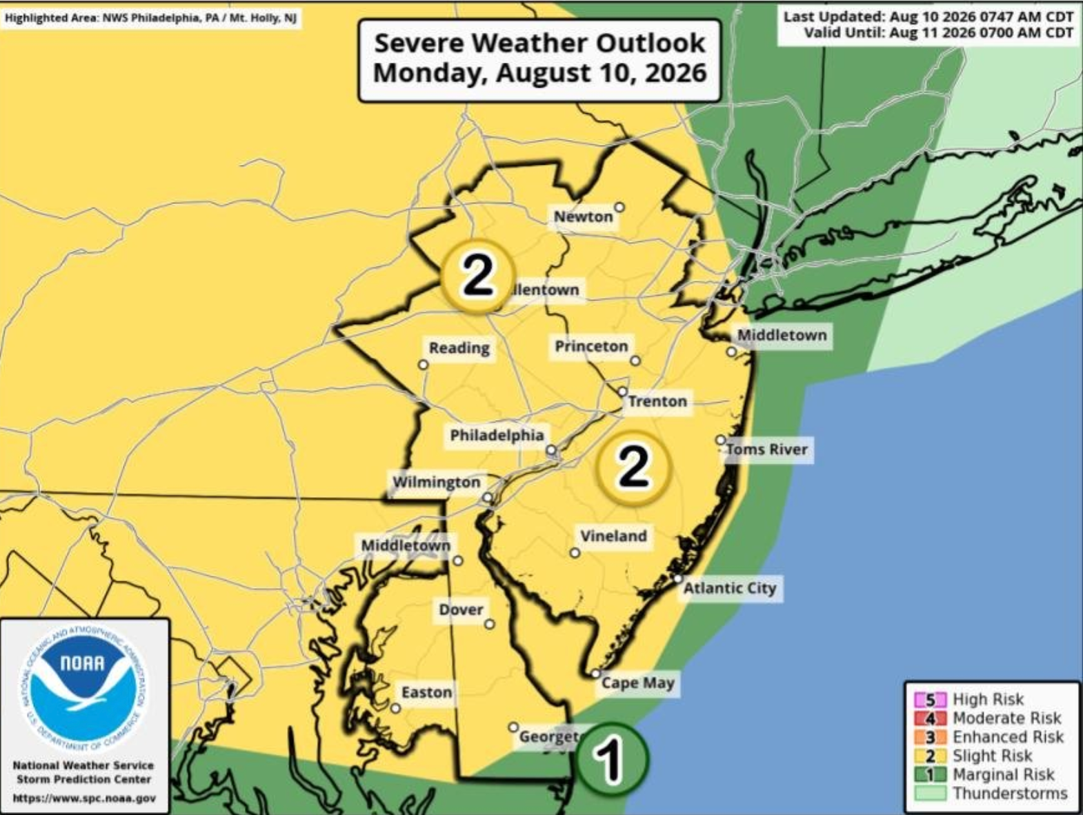
Not all areas will be hit by the severe storms, forecasters said, but residents are advised to remain on alert for changing weather conditions.
Find out what's happening in Across Pennsylvaniafor free with the latest updates from Patch.
Timing for the front is roughly from the middle of the afternoon through the evening.
Before the storms arrive, heat will soar into the mid-90s for much of the region.
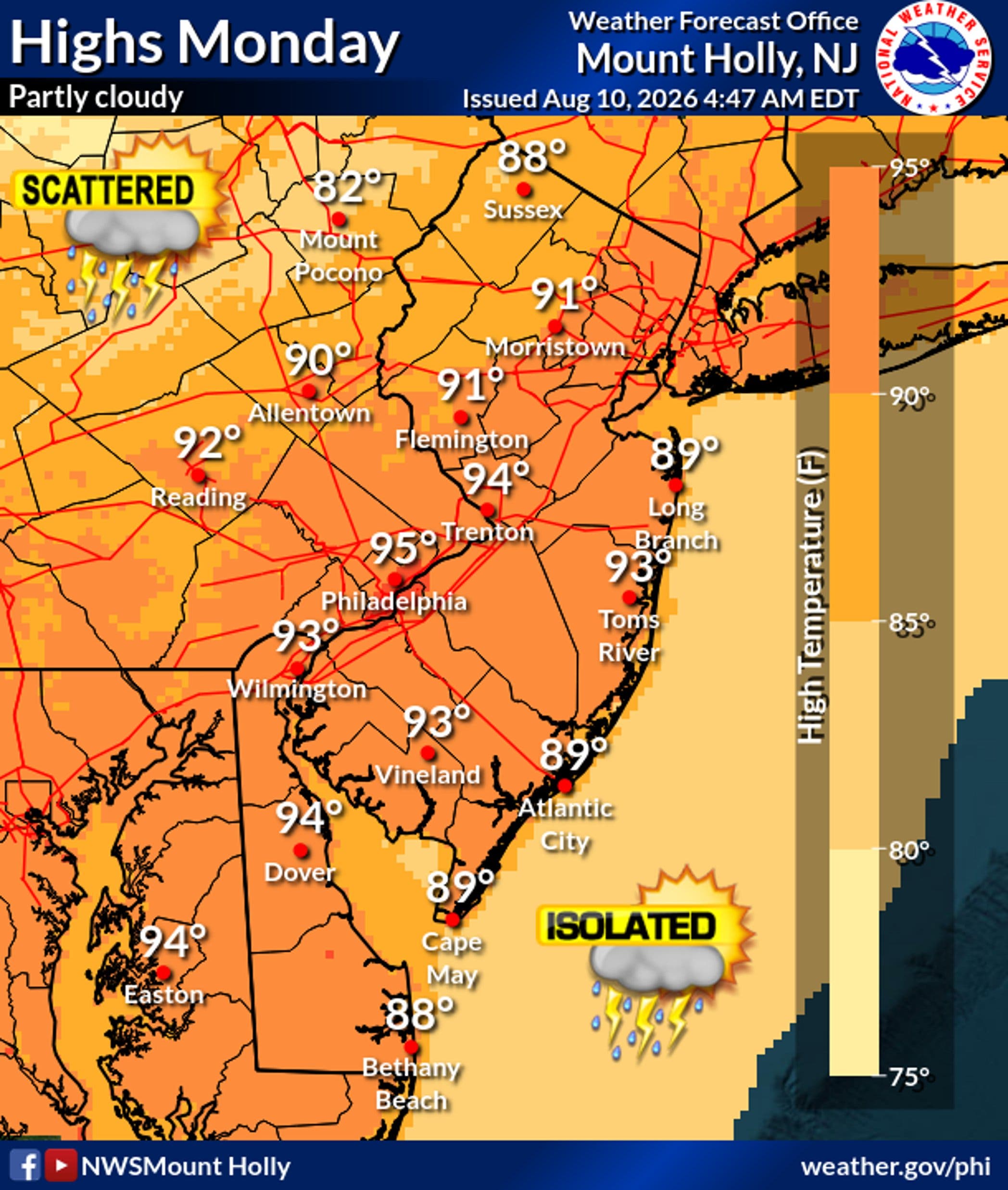
Monday will be the hottest day of the week, with temperatures cooling Tuesday and Wednesday and turning to much more comfortable weather by later in the week, forecasters said.
Here's the full forecast for the coming week in southeastern Pennsylvania:
Monday
Showers and thunderstorms likely, mainly after 5 p.m. Mostly sunny, with a high near 95 degrees. Light west wind increasing to 5 to 10 mph in the afternoon. Chance of precipitation is 60 percent. New rainfall amounts of less than a tenth of an inch, except higher amounts possible in thunderstorms.
Monday Night
Showers and thunderstorms likely, mainly before 11 p.m. Partly cloudy, with a low around 74 degrees. West wind around 5 mph. Chance of precipitation is 60 percent. New precipitation amounts of less than a tenth of an inch, except higher amounts possible in thunderstorms.
Tuesday
A chance of showers and thunderstorms, mainly after 4 p.m. Mostly sunny, with a high near 91 degrees. West wind 5 to 10 mph. Chance of precipitation is 30 percent. New rainfall amounts of less than a tenth of an inch, except higher amounts possible in thunderstorms.
Tuesday Night
A chance of showers and thunderstorms. Mostly cloudy, with a low around 72 degrees. Northwest wind around 5 mph becoming calm in the evening. Chance of precipitation is 40 percent. New rainfall amounts of less than a tenth of an inch, except higher amounts possible in thunderstorms.
Wednesday
A slight chance of showers after 2 p.m. Mostly sunny, with a high near 88 degrees. North wind around 5 mph becoming calm. Chance of precipitation is 20 percent.
Wednesday Night
A slight chance of showers, then a chance of showers and thunderstorms after 2 a.m. Partly cloudy, with a low around 72 degrees. Chance of precipitation is 30 percent. New rainfall amounts of less than a tenth of an inch, except higher amounts possible in thunderstorms.
Thursday
A chance of showers before 8 a.m. Mostly sunny, with a high near 89 degrees. Chance of precipitation is 30 percent.
Thursday Night
Mostly cloudy, with a low around 71 degrees.
Friday
Mostly sunny, with a high near 86 degrees.
Friday Night
Partly cloudy, with a low around 66 degrees.
Saturday
Mostly sunny, with a high near 85 degrees.
Get more local news delivered straight to your inbox. Sign up for free Patch newsletters and alerts.