Weather
Thunderstorms, Flash Flooding Forecast Again For Philly Area
The National Weather Service in Mount Holly has issued a flash flood watch for portions of southeastern Pennsylvania for later today.


PHILADELPHIA, PA — Isolated to scattered thunderstorms are forecast to develop today, especially across southeast PA, southern NJ, and Delmarva. The greatest risk of severe storms with damaging winds will be mainly near and south of Philadelphia, forecasters said.
There is also a risk of excessive rainfall, which has led forecasters to issue a Flash Flood Watch beginning at noon today and continuing into the evening.
Showers and thunderstorms are expected to develop this afternoon and evening, capable of producing heavy downpours. Rainfall rates of 1 to 2 inches per hour are likely and short term training of storms could result in flooding over southeast Pennsylvania, northern Delaware, and portions of southern New Jersey.
Find out what's happening in Doylestownfor free with the latest updates from Patch.
Excessive runoff may result in flooding of rivers,
creeks, streams, and other low-lying and flood-prone locations, forecasters say. Flooding may occur in areas with poor drainage and in urban areas.
The watch area includes the following counties in southeast Pennsylvania: Delaware, Eastern Chester, Eastern Montgomery, Lower Bucks, Philadelphia, Western Chester and Western Montgomery.
Find out what's happening in Doylestownfor free with the latest updates from Patch.
"There is also the signal for a marginal severe weather threat," National Weather Service forecasters said.
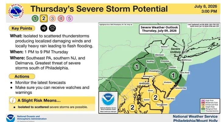
(National Weather Service, Mount Holly, N.J., graphic)
Another round of showers and thunderstorms moves in Friday, again with the possibility of heavy rain and flash flooding.
"So there looks to be at least some threat for severe weather once again," forecasters said.
Scattered showers and storms may linger into Saturday, forecasters said.
By Sunday, conditions will return to being dry and comfortable.
Forecast Details
Today - Showers and thunderstorms, mainly after 1 p.m. High near 84. South wind around 5 mph. The chance of precipitation is 80 percent. New rainfall amounts between a half and three quarters of an inch are possible.
Tonight - Showers and thunderstorms likely before 11 p.m., then a slight chance of showers between 11 p.m. and midnight. Mostly cloudy, with a low around 68. South wind around 5 mph becoming calm. The chance of precipitation is 60 percent. New precipitation amounts between a tenth and a quarter of an inch, except higher amounts are possible in thunderstorms.
Friday - A chance of showers and thunderstorms before 3 p.m., then a chance of showers and thunderstorms after 5 p.m. Increasing clouds, with a high near 87. West wind 5 to 10 mph. Chance of precipitation is 40 percent. New rainfall amounts of less than a tenth of an inch, except for higher amounts possible in thunderstorms.
Friday Night - A slight chance of showers and thunderstorms before 11 p.m., then a slight chance of showers between 11 p.m. and 2 a.m. Mostly cloudy, with a low around 66. West wind around 5 mph becoming calm. Chance of precipitation is 20 percent.
Saturday - A chance of showers and thunderstorms after 2 p.m. Partly sunny, with a high near 85. Northeast wind around 5 mph. Chance of precipitation is 30 percent. New rainfall amounts of less than a tenth of an inch, except for higher amounts possible in thunderstorms.
Saturday Night - A chance of showers and thunderstorms before 8 p.m. Partly cloudy, with a low around 62. Chance of precipitation is 30 percent. New precipitation amounts of less than a tenth of an inch, except higher amounts are possible in thunderstorms.
Sunday - Sunny, with a high near 84.
Get more local news delivered straight to your inbox. Sign up for free Patch newsletters and alerts.