Weather
Frost Advisory Issued In WI Before Thunderstorms Return
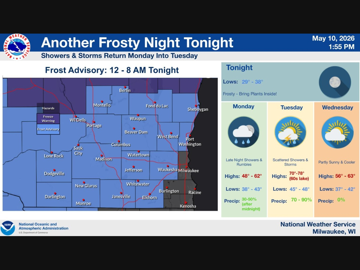
Southern Wisconsin could wake up to frost Monday before showers and thunderstorms move in later.

MILWAUKEE, WI — Southern Wisconsin is in for a chilly start to the week before a round of showers and thunderstorms arrives Monday night into Tuesday, according to the National Weather Service.
A frost advisory is in effect from midnight to 8 a.m. Monday for much of southern Wisconsin, including areas west and north of Milwaukee. Overnight lows are expected to fall into the upper 20s to upper 30s, according to the weather service.
The National Weather Service in Milwaukee warned residents to bring plants inside or protect sensitive outdoor vegetation from the cold.
Find out what's happening in Milwaukeefor free with the latest updates from Patch.
In Shorewood, the overnight low is expected to fall to about 37 degrees. Areas of frost are possible after 5 a.m., followed by a sunny but cool Monday, with a high near 52.
The weather will begin to shift Monday night, when showers become possible mainly after 4 a.m. Tuesday.
Find out what's happening in Milwaukeefor free with the latest updates from Patch.
Tuesday is expected to bring the most active weather of the week. Showers and thunderstorms are likely before 1 p.m., followed by more scattered showers and possibly a thunderstorm through the afternoon, according to the forecast.
The high Tuesday is expected to reach about 74 degrees in the Milwaukee area, though locations near Lake Michigan may stay cooler. South winds could increase to 15 to 20 mph, with gusts as high as 30 mph.
The chance of rain Tuesday is 90 percent, according to the National Weather Service. Rainfall amounts are expected to stay below a tenth of an inch in most places, though higher amounts are possible in thunderstorms.
Widespread severe weather is not expected at this time, the weather service said.
Here is the Milwaukee-area week-ahead forecast from NWS:
Monday: Areas of frost before 7 a.m. Otherwise, sunny, with a high near 52.
Monday night: A 30 percent chance of showers, mainly after 4 a.m. Increasing clouds, with a low around 40.
Tuesday: Showers and thunderstorms before 1 p.m., then showers likely and possibly a thunderstorm into the afternoon. High near 74. Breezy, with wind gusts up to 30 mph.
Tuesday night: A 30 percent chance of showers before 7 p.m. Partly cloudy, with a low around 47.
Wednesday: Partly sunny and cooler, with a high near 60.
Thursday: Sunny, with a high near 64.
Friday: A chance of showers, with thunderstorms also possible after 1 p.m. High near 69.
Get more local news delivered straight to your inbox. Sign up for free Patch newsletters and alerts.