Weather
Triple-Digit Heat And Monsoonal Moisture To Boil The Southland
Forecasters said the heat wave will start Tuesday, peaking Thursday at 110 degrees in parts of Southern California.

LOS ANGELES, CA — Dangerous heat and a chance of isolated storms are expected to create extreme fire danger as the Southland braces for its hottest week this year, according to the National Weather Service.
National Weather Service forecasters said the heat wave will set in Tuesday and climb over the following days as a ridge of high-pressure builds over the region. Triple-digit temperatures are expected to cook inland areas, with a high of 110 degrees expected Thursday in Palm Desert and a scorching 120 degrees in Death Valley. The sizzling heat wave won't begin to loosen its grip until the end of the week as low pressure troughs on both sides of the region.
"There is still some uncertainty in exactly how hot temperatures will get, but current forecast highs on Wednesday show ... 100s expected for the Inland Empire, High Desert and eastern San Diego valleys, and 90s for the western valleys and lower elevations of the mountains," according to the National Weather Service.
Find out what's happening in Los Angelesfor free with the latest updates from Patch.
Forecasters said the "combination of hot and moderately dry conditions with gusty onshore winds" were bringing elevated fire weather conditions across the interior, and "critical fire weather conditions" are possible Wednesday afternoon and Thursday morning for interior areas.
Extreme Inland Heat
Extreme Heat Warnings have been issued for parts of the Coachella Valley in Riverside County and the Riverside metropolitan area, stretching east to Idyllwild-Pine Cove, starting at 10 a.m. Wednesday and ending at 8 p.m. Thursday.
Find out what's happening in Los Angelesfor free with the latest updates from Patch.
"The ridge is going to be building closer in the coming days. It looks like the peak temperatures are going to Wednesday through Thursday. Friday will cool down substantially with temps more normal Friday into the weekend," said National Weather Service Meteorologist Sebastian Westrink.
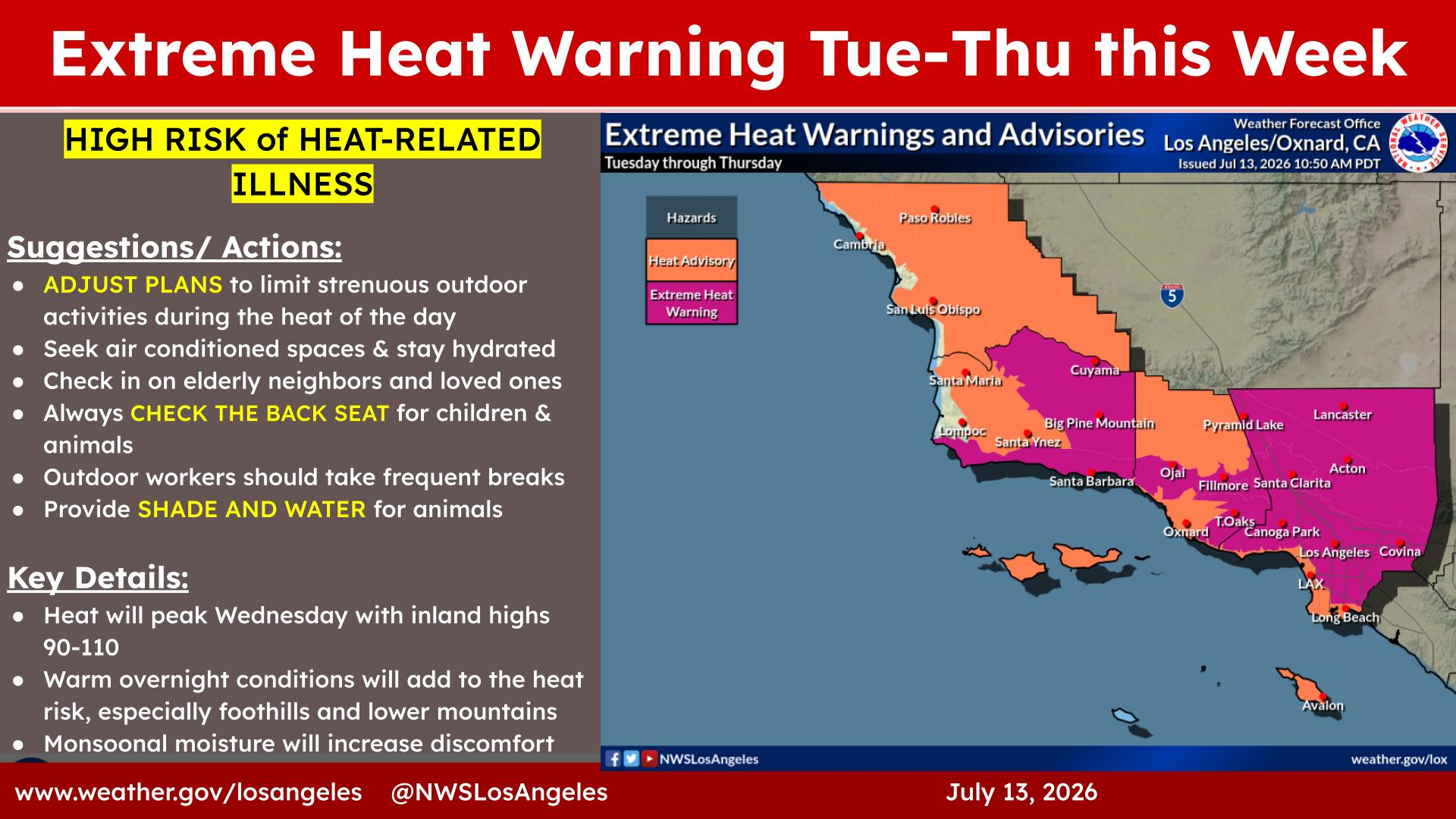
In Riverside metro, the daytime mercury on Monday will crest in the mid 90s, followed by upper 90s on Tuesday, while on Wednesday and Thursday, highs will top out in the low 100s, according to meteorologists. They said a moderation will begin Friday, with peak heat in the low to mid 90s for Riverside and surrounding locations. Weekend daytime temps are forecast to hover in the low 90s. Lows are expected to settle in the low to mid 70s all week.
In the Coachella Valley on Monday and Tuesday, highs will settle around 105, but on Wednesday and Thursday, they may peak closer to 115, with slight cooling going into the weekend. Lows will generally hover in the mid to upper 80s all week long.
The Temecula Valley will see temps cresting in the low to mid 90s Monday and Tuesday, approaching 100 on Wednesday and Thursday, and trending back to just below 90 on Friday and through the weekend, according to the Weather Service. Lows are forecast to be in the mid 60s to the end of the week.
Highs are expected to reach triple digits in parts of the San Fernando, Santa Clarita and Antelope valleys Wednesday and Thursday, with Wednesday likely seeing the highest numbers.
Forecasters are calling for highs of 87 and 91 degrees in downtown Los Angeles on Wednesday and Thursday. In Lancaster, those highs will be 103 and 100, and in Van Nuys, highs of 101 and 95 degrees are expected mid-week.
A heat advisory will also be in effect from 10 a.m. Tuesday to 8 p.m. Thursday for Los Angeles County beaches and the Palos Verdes Hills, but some of those coastal areas could see temperatures ranging from 85 to 105 degrees, according to the weather service.
An extreme heat warning will also be in place for inland Orange County areas from 10 a.m. Wednesday to 8 p.m. Thursday, with a heat advisory in place during the same time frame for Orange County coastal areas.
Thunderstorms and Monsoonal Moisture
According to the National Weather Service, thunderstorms are possible in the mountain areas, with highs expected in the mid-80s. The chances of thunderstorms will diminish by Monday night, though humidity levels will remain elevated. Isolated thunderstorms will remain possible in elevated areas by Wednesday and Thursday as well, forecasters said.
The weather service prognostication charts indicated that the pattern won't change dramatically, but enough to allow moisture drawn into Southern California from Arizona and Mexico to generate monsoonal activity in the mountains and deserts on Friday and through the weekend.
The agency recommended taking all necessary precautions, including finding shade when the heat is most intense, staying close to air conditioners and remaining hydrated.
City News Service contributed to this report.
Get more local news delivered straight to your inbox. Sign up for free Patch newsletters and alerts.