Weather
Dangerous Heat To Scorch VA, Storm Chances Return: July 4 Weekend Forecast
Multiple extreme heat warnings are in effect for Northern Virginia as residents head into the holiday weekend. See the latest forecast.

As Virginians prepare to celebrate the Fourth of July, sweltering heat and humidity could make this weekend's outdoor festivities not only uncomfortable but potentially dangerous. Meanwhile, the return of showers and thunderstorms could also disrupt some holiday plans.
Virginia is one of several states sweating under a massive heat dome that will linger for several days and bring the hottest weather so far this year for many, according to the latest forecasts.
Heading into the weekend, an extreme heat warning remains in effect until 8 p.m. Thursday. The warning will be in place again on Friday from 10 a.m. to 8 p.m.
Find out what's happening in Old Town Alexandriafor free with the latest updates from Patch.
On Thursday, Northern Virginia residents should expect dangerously hot conditions with heat index values up to 111 degrees, according to the National Weather Service. The extreme heat will persist on Friday, with heat index values up to 112 degrees expected.
"Heat-related illnesses increase significantly during
extreme heat and high humidity events," NWS forecasters wrote. "Drink plenty of fluids, stay in an air-conditioned room, stay out of the sun, and check up on relatives and neighbors."
Find out what's happening in Old Town Alexandriafor free with the latest updates from Patch.
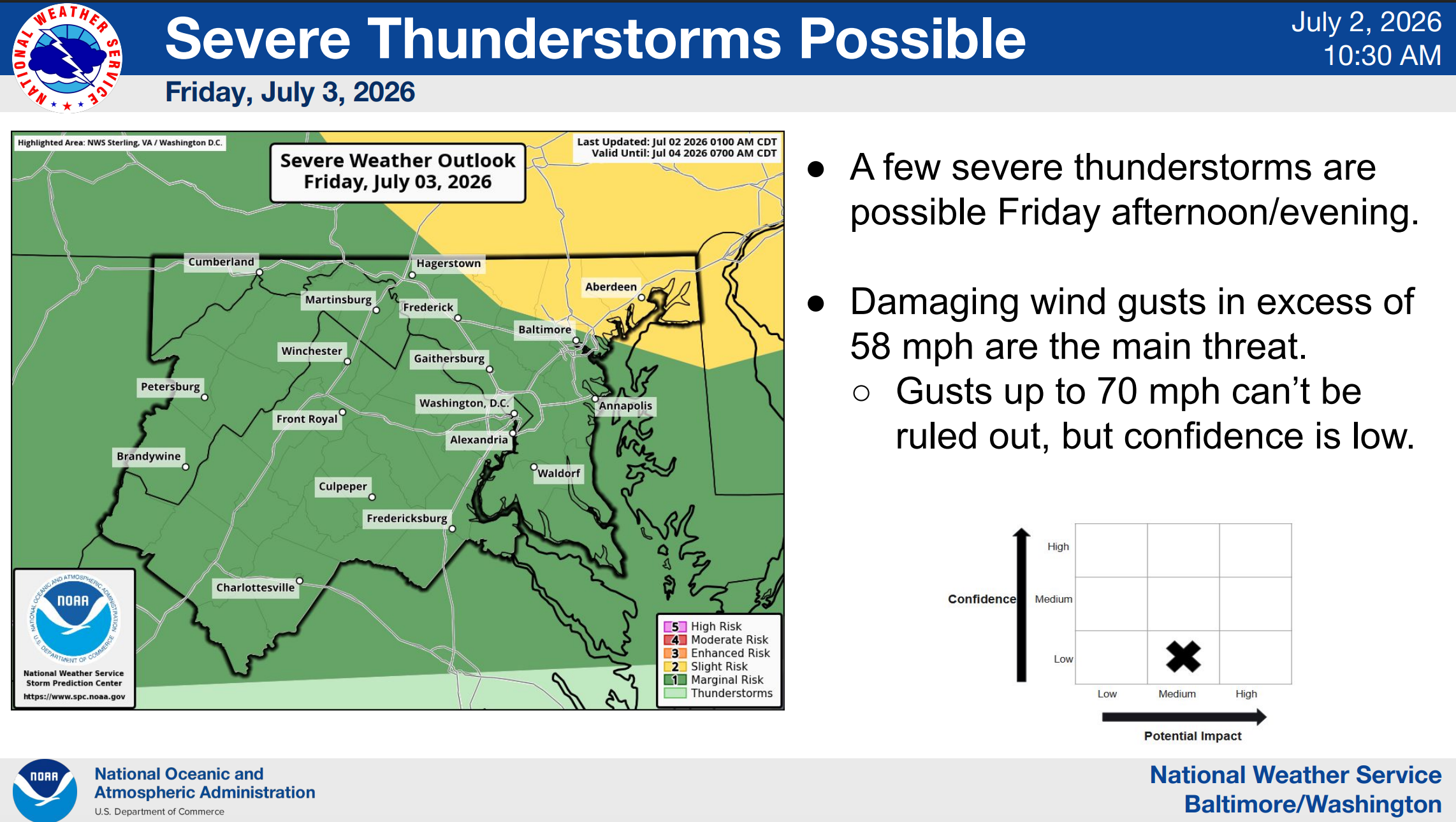
Meanwhile, storm chances return to the Baltimore region Friday afternoon and evening. According to forecasts, severe thunderstorms are possible after 2 p.m., with damaging wind gusts as the main threat.
Unfortunately, any potential rainfall will offer little relief from the heat heading into Independence Day.
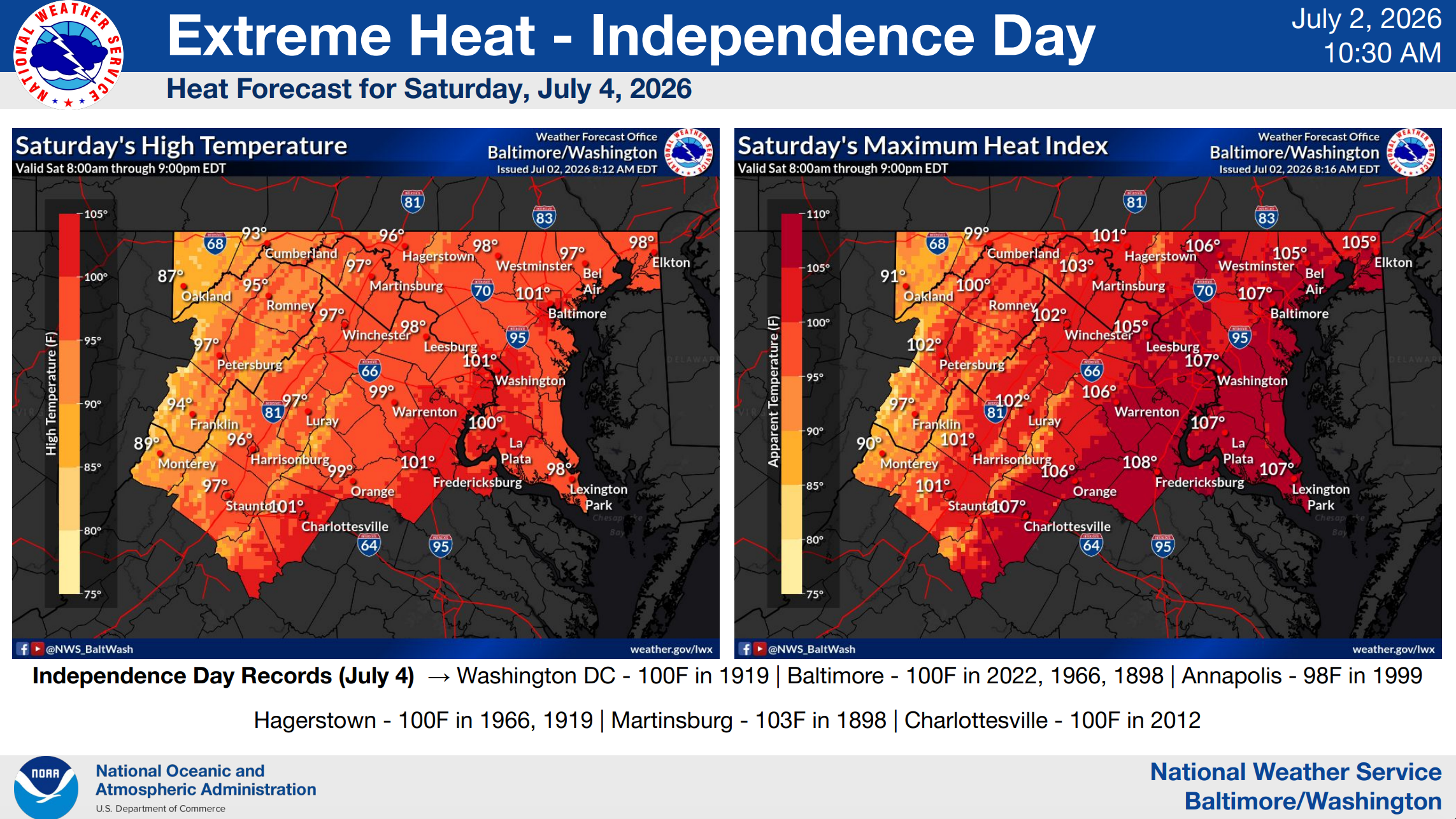
An extreme heat watch is in effect Saturday morning through Saturday evening for areas east of the Blue Ridge Mountains. Dangerously hot conditions are expected to continue, with heat index values up to 110 degrees possible.
Severe thunderstorms are also possible Saturday afternoon and evening, with damaging wind gusts as the main threat.
Significant heat will linger into Sunday as the holiday weekend draws to a close. Showers are likely and a thunderstorm is possible after 2 p.m., according to forecasters. Expect partly sunny conditions, with a high near 96 degrees.
Here's a look at the detailed forecast for Northern Virginia:
Thursday: Sunny and hot, with a high near 102. Heat index values as high as 110. North wind around 5 mph becoming calm.
Thursday Night: Clear, with a low around 78. Light and variable wind.
Friday: A slight chance of showers and thunderstorms after 2pm. Sunny and hot, with a high near 102. Heat index values as high as 111. Calm wind becoming west around 6 mph in the afternoon. Chance of precipitation is 20%.
Friday Night: Partly cloudy, with a low around 77. West wind around 5 mph becoming calm in the evening.
Saturday: Showers and thunderstorms likely after 2pm. Mostly sunny and hot, with a high near 99. Calm wind becoming west 5 to 7 mph in the afternoon. Chance of precipitation is 60%.
Saturday Night: Showers and thunderstorms likely, mainly before 8pm. Mostly cloudy, with a low around 74. Chance of precipitation is 60%.
Sunday: Showers likely and possibly a thunderstorm after 2pm. Partly sunny, with a high near 96. Chance of precipitation is 60%.
Sunday Night: Showers likely and possibly a thunderstorm before 2am, then a slight chance of showers. Mostly cloudy, with a low around 72. Chance of precipitation is 60%.
Monday: A chance of showers, then showers likely and possibly a thunderstorm after 2pm. Mostly cloudy, with a high near 90. Chance of precipitation is 70%.
Get more local news delivered straight to your inbox. Sign up for free Patch newsletters and alerts.