Weather
Severe Storms To Lash VA With Damaging Winds, Heavy Rain: See Latest Alerts
Much of Northern Virginia is under a severe thunderstorm watch as multiple rounds of storms move through the region.


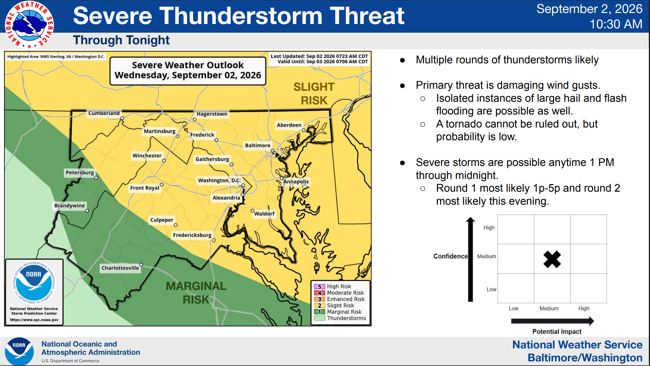
A severe thunderstorm watch is in effect across Northern Virginia and Washington, D.C., until 5 p.m. Wednesday, with multiple rounds of storms possible through the night.
The watch includes Arlington, Fairfax, Loudoun and Prince William counties, along with the cities of Alexandria, Fairfax City, Falls Church, Manassas and Manassas Park. Farther south, Stafford and Spotsylvania counties and Fredericksburg are also included.
The National Weather Service said damaging winds are the biggest concern Wednesday, although some storms could also bring large hail and flash flooding. A tornado cannot be ruled out, but forecasters said the chance is low.
Find out what's happening in Old Town Alexandriafor free with the latest updates from Patch.
Storms could turn severe anytime between 1 p.m. and midnight, with one round most likely between 1 and 5 p.m. and another possible Wednesday evening.
More Storms Ahead
The unsettled weather won't necessarily end Wednesday.
Find out what's happening in Old Town Alexandriafor free with the latest updates from Patch.
Another round of thunderstorms is possible Thursday afternoon and evening, with damaging winds again the primary concern. Large hail and flash flooding are also possible.
More storms could develop Friday afternoon and evening, although uncertainty remains about where the strongest storms will occur.
It will remain hot and humid through the end of the workweek, with heat index values around 100 to 105 degrees possible Thursday and Friday. Cooler and quieter weather is expected heading into the weekend.
Detailed Northern Virginia Forecast
Wednesday: Scattered showers and thunderstorms before 2pm, then showers likely and possibly a thunderstorm between 2pm and 5pm, then scattered showers and thunderstorms after 5pm. Some of the storms could be severe. Mostly cloudy, with a high near 90. Northeast wind around 7 mph becoming southeast. Chance of precipitation is 60%. New rainfall amounts between a tenth and quarter of an inch, except higher amounts possible in thunderstorms.
Wednesday Night: Scattered showers and thunderstorms, mainly before 8pm. Mostly cloudy, then gradually becoming mostly clear, with a low around 73. Southeast wind around 6 mph becoming calm in the evening. Chance of precipitation is 30%.
Thursday: Mostly sunny, with a high near 94. Heat index values as high as 105. Calm wind becoming west 5 to 7 mph in the afternoon.
Thursday Night: A slight chance of showers and thunderstorms between 7pm and 8pm. Partly cloudy, with a low around 75. Light and variable wind. Chance of precipitation is 20%.
Friday: A chance of showers and thunderstorms after 2pm. Mostly sunny, with a high near 93. Light northwest wind increasing to 5 to 9 mph in the morning. Chance of precipitation is 50%.
Friday Night: A chance of showers and thunderstorms before 11pm, then a chance of showers between 11pm and 2am. Mostly cloudy, with a low around 71. Chance of precipitation is 40%.
Saturday: Mostly sunny, with a high near 86.
Saturday Night: Partly cloudy, with a low around 63.
Sunday: Sunny, with a high near 83.
Get more local news delivered straight to your inbox. Sign up for free Patch newsletters and alerts.