Weather
Updated Nor'easter Forecast: Rain, Wind, Coastal Flooding Predicted For NoVA
Northern Virginia could receive 1 to 2 inches of rain before drier weather arrives Thursday, while tidal flooding threatens some areas.


A developing nor’easter will keep Northern Virginia cool, rainy and windy through Wednesday, but the latest forecast suggests the storm’s most damaging effects will remain closer to the coast and shift toward New England later this week.
AccuWeather said a storm over the Atlantic is expected to take shape and evolve into a significant nor’easter. How strong the storm becomes and how close to the coast it gets will determine which areas are likely to experience the worst damage from storm surge, beach erosion and wind.
In Northern Virginia, most of the region could receive 1 to 2 inches of rain before showers taper off from northeast to southwest Wednesday afternoon and evening, according to the National Weather Service.
Find out what's happening in Old Town Alexandriafor free with the latest updates from Patch.
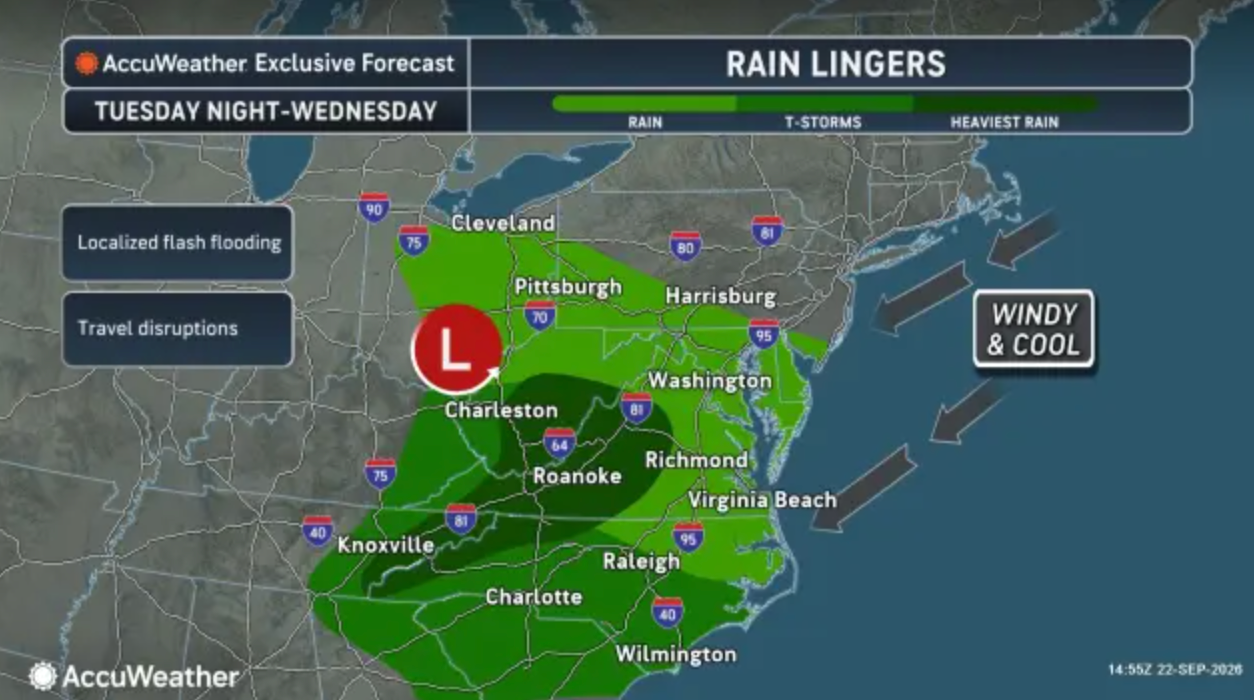
Isolated flooding is also possible Tuesday and Tuesday night, particularly in urban areas and places with poor drainage.
High temperatures Tuesday and Wednesday will remain in the upper 50s to mid-60s. Northeast winds could gust from 15 to 30 mph, making conditions feel cooler.
Find out what's happening in Old Town Alexandriafor free with the latest updates from Patch.
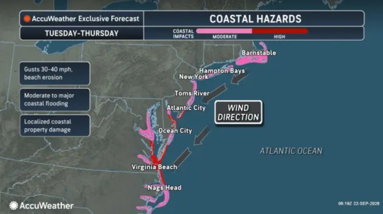
The persistent winds are expected to push water into the Chesapeake Bay and the rivers that feed it, including the Potomac.
As a result, a coastal flood advisory is in effect from 4 p.m. Tuesday through 8 p.m. Wednesday along the Potomac River shoreline in Alexandria and Arlington County. Up to 2 feet of water above ground level is possible in low-lying areas, especially around high tide.
Tides are expected to run 1.5 to 2 feet above normal. In Old Town Alexandria, water could approach the curb near King and Strand streets. The next high tides in Alexandria are expected around 6:25 p.m. Tuesday and 6:38 a.m. Wednesday.
Rain should end by Wednesday night in the D.C. region. Thursday will remain mostly cloudy, cool and breezy, with highs in the 60s, before skies gradually clear Friday. Dry weather is expected through the weekend, although gusty winds could continue through Saturday or Sunday.
Detailed Northern Virginia Forecast
Tuesday: Rain and possibly a thunderstorm. Patchy fog. High near 62. Northeast wind around 10 mph, with gusts as high as 25 mph. Chance of precipitation is 100%. New rainfall amounts between a tenth and quarter of an inch, except higher amounts possible in thunderstorms.
Tuesday Night: Rain with patchy drizzle. Patchy fog. Low around 54. Northeast wind around 9 mph, with gusts as high as 21 mph. Chance of precipitation is 100%. New precipitation amounts between a half and three quarters of an inch possible.
Wednesday: Rain likely, mainly before 8am. Cloudy, with a high near 65. Northeast wind around 10 mph, with gusts as high as 24 mph. Chance of precipitation is 60%. New precipitation amounts between a tenth and quarter of an inch possible.
Wednesday Night: Cloudy, then gradually becoming partly cloudy, with a low around 51. Northeast wind around 8 mph.
Thursday: Partly sunny, with a high near 65. Northeast wind 9 to 11 mph, with gusts as high as 20 mph.
Thursday Night: Partly cloudy, with a low around 48.
Friday: Mostly sunny, with a high near 68.
Friday Night: Partly cloudy, with a low around 51.
Saturday: Mostly sunny, with a high near 68.
Saturday Night: Partly cloudy, with a low around 53.
Sunday: Mostly sunny, with a high near 71.
Get more local news delivered straight to your inbox. Sign up for free Patch newsletters and alerts.