Weather
NoVA Faces Triple Threat From Hurricane Isaias Remnants
Northern Virginia could see 1.5 to 2.5 inches of rain, isolated tornadoes and gusts up to 50 mph in the Blue Ridge Mountains.


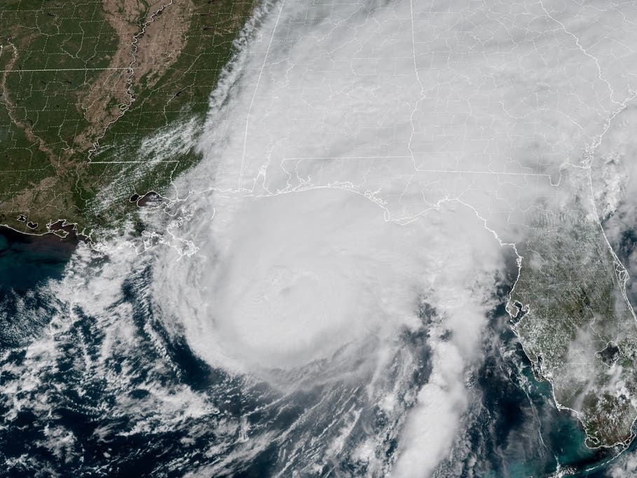
The remnants of Hurricane Isaias are expected to bring heavy rain, damaging thunderstorms and possible tornadoes to Northern Virginia this weekend, with the worst weather arriving Sunday, according to the National Weather Service.
Forecasters have increased expected rainfall totals to 1.5 to 2.5 inches across the Baltimore-Washington region, with isolated amounts of 3 to 4 inches possible.
The heaviest rain could fall along the eastern slopes of the Blue Ridge Mountains, while thunderstorms capable of producing damaging winds and brief tornadoes could develop farther east.
Find out what's happening in Across Virginiafor free with the latest updates from Patch.
A wind advisory is in effect for portions of the Blue Ridge Mountains, where gusts could reach 40 to 50 mph. Elsewhere, including the Washington suburbs, gusts of 20 to 30 mph are expected outside thunderstorms.
.jpg)
When Will Isaias Hit Northern Virginia?
Rain could reach central Virginia by Saturday afternoon, then spread north into the Washington, D.C., suburbs on Saturday night.
Find out what's happening in Across Virginiafor free with the latest updates from Patch.
The National Weather Service expects the most widespread and intense rainfall Sunday morning into early afternoon, with localized flooding possible where heavier downpours develop.
By Sunday afternoon, forecasters expect a break in the widespread rain that could allow thunderstorms to form across the region.
The greatest severe weather threat is expected east of the Blue Ridge Mountains, including the Northern Virginia suburbs. A few brief tornadoes and damaging wind gusts are possible Sunday afternoon and evening.
The Storm Prediction Center has placed much of the region under a marginal risk for severe thunderstorms, with a higher risk extending into portions of central and southern Virginia.
Some showers could linger into Monday morning before the storm system moves offshore and conditions improve.
Wind Advisory Issued For Blue Ridge Mountains
A wind advisory is in effect from 2 a.m. to 11 a.m. Sunday for the northern and central Virginia Blue Ridge Mountains, including mountainous portions of Loudoun, Fauquier, Rappahannock and neighboring counties.
Easterly winds could gust up to 50 mph in higher elevations, potentially bringing down tree limbs and causing scattered power outages.
In lower-elevation communities, including Fairfax, Arlington, Alexandria, Manassas and Fredericksburg, winds are expected to be less intense, although stronger gusts could accompany thunderstorms.
.jpg)
Flooding Possible Along Potomac River
In addition to heavy rainfall, forecasters are monitoring the potential for tidal flooding along the Potomac River on Sunday afternoon and evening.
Strong onshore winds are expected to push water into the Chesapeake Bay and tidal Potomac River, coinciding with high tides and a new moon.
Minor tidal flooding is possible in low-lying waterfront areas, including portions of Alexandria and other communities along the Potomac.
Water levels should begin falling Monday morning as winds shift offshore.
Boaters on the tidal Potomac should also prepare for hazardous conditions, with gusty winds and the possibility of thunderstorms producing waterspouts.
Latest On Hurricane Isaias
Isaias weakened to a post-tropical cyclone Saturday after making landfall near Destin, Florida, as a Category 2 hurricane on Friday night.
At 11 a.m. ET Saturday, the storm was centered about 50 miles south of Birmingham, Alabama, with maximum sustained winds of 35 mph, according to the National Weather Prediction Center.
The system was moving north-northwest at 10 mph and was expected to continue weakening as it moved inland.
Despite losing its tropical characteristics, Isaias continued to threaten flash flooding, damaging winds and severe thunderstorms across parts of the southeastern United States.
The storm has been blamed for at least two deaths, one in Florida and another in Alabama, after trees fell onto homes. Hundreds of thousands of customers also lost electricity across Florida, Alabama and Georgia as the hurricane moved inland.
AccuWeather reported that roughly 800,000 customers across parts of the Southeast remained without power around midday Saturday.
Isaias is expected to continue moving north through the Tennessee Valley before its remnants turn eastward and spread rain and gusty winds across the Mid-Atlantic and Northeast.
Although Northern Virginia is not expected to experience hurricane-force winds, forecasters emphasized that the storm's remnants could still produce hazardous weather, particularly Sunday.
Northern Virginia residents should secure loose outdoor objects, prepare for possible power outages and avoid driving through flooded roads. Residents should also monitor weather alerts Sunday, especially in the afternoon and evening, when the tornado threat is expected to be greatest.
Latest Northern Virginia Forecast
Saturday: Cloudy, with a high near 71. East wind around 8 mph.
Saturday Night: Showers, mainly after 2am. Low around 59. East wind 7 to 9 mph. Chance of precipitation is 80%. New precipitation amounts between a quarter and half of an inch possible.
Sunday: Showers, with thunderstorms also possible after 5pm. High near 69. East wind 13 to 15 mph, with gusts as high as 29 mph. Chance of precipitation is 100%. New rainfall amounts between three quarters and one inch possible.
Sunday Night: Showers and possibly a thunderstorm. Low around 62. East wind 5 to 7 mph becoming west in the evening. Chance of precipitation is 80%. New precipitation amounts between a quarter and half of an inch possible.
Monday: A chance of showers before 8am. Partly sunny, with a high near 74. Northwest wind 11 to 15 mph, with gusts as high as 25 mph. Chance of precipitation is 30%.
Monday Night: Mostly clear, with a low around 57.
Tuesday: Sunny, with a high near 80.
Tuesday Night: A slight chance of showers before 2am. Partly cloudy, with a low around 59. Chance of precipitation is 20%.
Wednesday: Sunny, with a high near 71.
Get more local news delivered straight to your inbox. Sign up for free Patch newsletters and alerts.