Weather
Potential Nor'easter Could Bring Season's First Snow To VA: See Where
Mountain snow, gusty winds and the coldest temperatures of the season are possible as a developing coastal storm approaches the East.


Winter may be ready to make an early appearance in Virginia this weekend, with a potential nor'easter bringing the chance of the season's first snow, gusty winds and a serious drop in temperatures.
But before anyone starts hunting for snow shovels, there's a catch: The best chances for accumulating snow are in the mountains, while Northern Virginia's suburbs are more likely to see chilly temperatures than a winter wonderland.
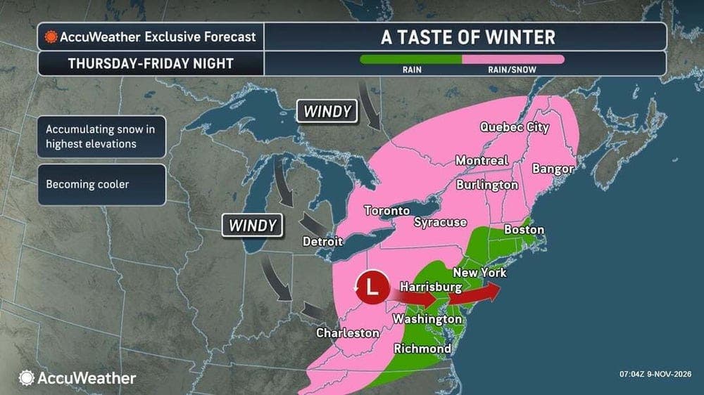
A developing storm system could strengthen along the East Coast late this week, potentially becoming a nor'easter and bringing rain, snow and strong winds to portions of the eastern United States, according to The Weather Channel.
Find out what's happening in Across Virginiafor free with the latest updates from Patch.
The exact track remains uncertain, meaning the forecast could change as the weekend approaches.
Where Could Snow Fall In Virginia?
The National Weather Service's Baltimore/Washington office says the first accumulating snow of the season is likely Friday into Saturday at higher elevations in the Allegheny Mountains.
Find out what's happening in Across Virginiafor free with the latest updates from Patch.
That includes mountainous areas of western Virginia, where snow could create some travel headaches.
Forecasters say snow could also reach the highest peaks farther east toward the Blue Ridge Mountains, although that scenario is considered unlikely.
Winds could gust as high as 40 mph at times in the mountains, adding another challenge for anyone traveling through the region.
For communities along the Interstate 95 corridor, including Alexandria, Arlington, Fairfax, Fredericksburg and Stafford, the outlook is considerably less snowy.
The Weather Channel says temperatures along I-95 are expected to remain too warm for snow in major metropolitan areas. Its forecast places the best chances for accumulating snow in the Appalachians and other higher elevations of the Northeast.
AccuWeather agrees that the mountains offer the best chance of seeing snow stick.
"This storm will likely bring the first snowflakes of the season to many interior locations, though the exact track and intensity of the storm will dictate where," AccuWeather senior meteorologist Adam Douty said.
Douty added that snow will have difficulty accumulating outside higher elevations.
A Nor'easter In November?
Nor'easters aren't just winter storms. They develop when low-pressure systems along the East Coast produce winds blowing from the northeast, and they can bring rain, coastal flooding and strong winds even when temperatures are too warm for snow.
According to The Weather Channel, a low-pressure system is expected to strengthen as it moves through the Ohio Valley Wednesday night. Another area of low pressure could develop off the East Coast by Thursday night.
From there, the storm's track will determine how much rain, snow and wind reaches the region.
A storm tracking closer to the coastline could bring stronger winds, heavier precipitation and coastal flooding to some areas. A track farther offshore would generally mean lighter impacts.
Forecasters have not settled on which scenario will unfold, so the potential nor'easter remains something to watch rather than a guaranteed major storm for Virginia.
Freezing Temperatures Could Be The Bigger Story
Even if snow skips most of Northern Virginia, the cold won't.
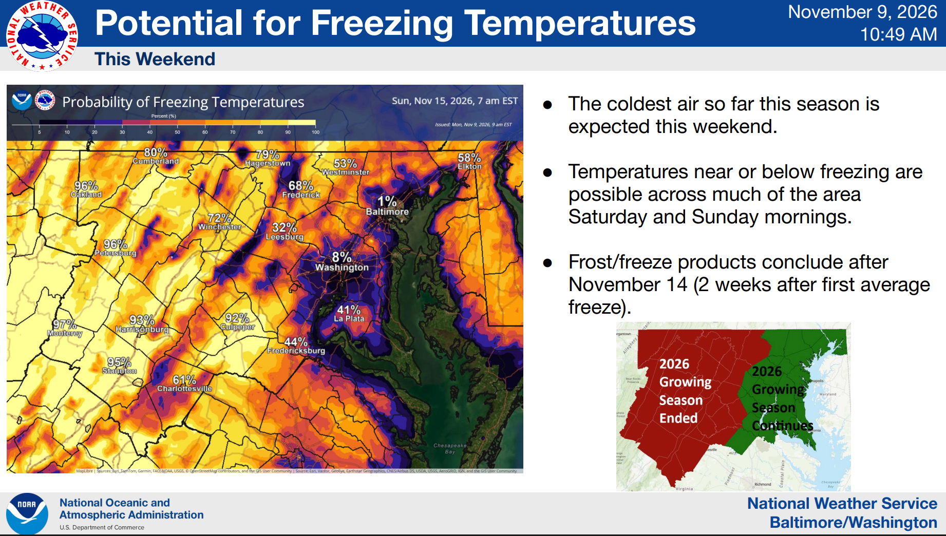
The National Weather Service expects the coldest air of the season to arrive this weekend, with temperatures near or below freezing possible across much of the region Saturday and Sunday mornings.
That could mean frosty windshields, chilly morning walks and a rude awakening for any plants still enjoying the mild fall weather.
The Weather Channel says a major dip in the jet stream will send colder air sweeping across the eastern United States, with temperatures dropping sharply from midweek into Friday.
AccuWeather also expects freezing temperatures to spread across parts of the central and eastern United States, potentially ending the growing season in some communities.
Residents with sensitive outdoor plants may want to bring them inside or cover them before the weekend. It's also a good time to check outdoor faucets and make sure pets have a warm place to stay.
What Happens After The Cold Snap?
The chilly weather may not stick around for long.
The National Weather Service Climate Prediction Center's outlook for Nov. 16-22 favors above-normal temperatures across Virginia, along with a tendency toward below-normal precipitation.
In other words, winter may be making a quick visit rather than moving in for good.
For now, the biggest things to watch are the storm's track, the potential for accumulating mountain snow and how far temperatures fall over the weekend.
Northern Virginia Forecast
Tuesday: Sunny, with a high near 70. Southwest winds of 5 to 13 mph, becoming westerly in the afternoon.
Tuesday Night: Mostly clear, with a low around 42. Light winds.
Wednesday: Partly sunny, with a high near 68. Light southerly winds.
Wednesday Night: Mostly cloudy, with a slight chance of rain after 1 a.m. Low around 47. Chance of precipitation is 20%.
Thursday: Rain likely, with mostly cloudy skies and a high near 63. Northwest winds increasing to 6 to 11 mph in the afternoon. Chance of precipitation is 70%.
Thursday Night: Mostly cloudy, with a chance of rain, mainly after 1 a.m. Low around 40. Chance of precipitation is 40%.
Friday: Partly sunny and cooler, with a chance of rain before 1 p.m. High near 50. Chance of precipitation is 30%.
Friday Night: Partly cloudy, with a low around 33.
Saturday: Partly sunny, breezy and chilly, with a high near 50.
Saturday Night: Partly cloudy, with a low around 34.
Sunday: Mostly sunny, with a high near 53.
Sunday Night: Partly cloudy, with a low around 32.
Monday: Mostly sunny, with a high near 54.
Get more local news delivered straight to your inbox. Sign up for free Patch newsletters and alerts.